
Carte topographique Dothan
Carte interactive
Cliquez sur la carte pour afficher l’altitude.
À propos de cette carte
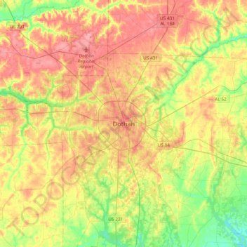
Nom : Carte topographique Dothan, altitude, relief.
Lieu : Dothan, Houston County, Alabama, 36303-5834, United States (31.06374 -85.55339 31.38374 -85.23339)
Altitude moyenne : 83 m
Altitude minimum : 38 m
Altitude maximum : 128 m
Autres cartes topographiques
Cliquez sur une carte pour visualiser sa topographie, son altitude et son relief.
Pine Ridge Estates
United States > Alabama > Houston County > Dothan
Pine Ridge Estates, Dothan, Houston County, Alabama, 36305, United States
Altitude moyenne : 90 m
Rock Creek Park
United States > Alabama > Houston County > Dothan
Rock Creek Park, Dothan, Houston County, Alabama, 36303, United States
Altitude moyenne : 91 m
Silver Meadows
United States > Alabama > Houston County > Dothan
Silver Meadows, Dothan, Houston County, Alabama, 36305, United States
Altitude moyenne : 90 m
Kelly Springs
United States > Alabama > Houston County > Dothan
Kelly Springs, Dothan, Houston County, Alabama, 36303, United States
Altitude moyenne : 97 m