
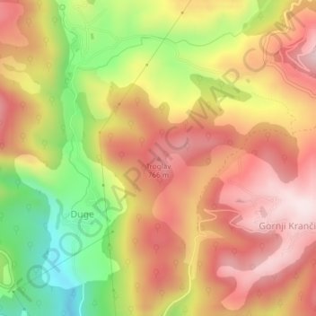
Carte topographique Troglav
Carte interactive
Cliquez sur la carte pour afficher l’altitude.
À propos de cette carte
Nom : Carte topographique Troglav, altitude, relief.
Altitude moyenne : 629 m
Altitude minimum : 369 m
Altitude maximum : 818 m
Autres cartes topographiques
Cliquez sur une carte pour visualiser sa topographie, son altitude et son relief.
Police
B&H > Entity Federation of Bosnia and Herzegovina > Police
Police, City of Široki Brijeg, West Herzegovina Canton, Entity Federation of Bosnia and Herzegovina, 88226, B&H
Altitude moyenne : 418 m
Donja Trebimlja
B&H > Entity Federation of Bosnia and Herzegovina > Donja Trebimlja
Donja Trebimlja, Ravno municipality, Herzegovina-Neretva Canton, Entity Federation of Bosnia and Herzegovina, B&H
Altitude moyenne : 486 m
Orguz
B&H > Entity Federation of Bosnia and Herzegovina > Orguz
Orguz, City of Livno, Canton 10, Entity Federation of Bosnia and Herzegovina, B&H
Altitude moyenne : 846 m
Donji Tiškovac
B&H > Entity Federation of Bosnia and Herzegovina > Donji Tiškovac
Donji Tiškovac, Bosansko Grahovo municipality, Canton 10, Entity Federation of Bosnia and Herzegovina, B&H
Altitude moyenne : 619 m
Galičica
B&H > Entity Federation of Bosnia and Herzegovina > Galičica
Galičica, Gornji Vakuf/Uskoplje municipality, Central Bosnia Canton, Entity Federation of Bosnia and Herzegovina, 70240, B&H
Altitude moyenne : 796 m
Čvrsnica
B&H > Entity Federation of Bosnia and Herzegovina > Turističko naselje Risovac
Čvrsnica, Put munike, Zelenike, Naselje Risovac, Turističko naselje Risovac, Jablanica municipality, Herzegovina-Neretva Canton, Entity Federation of Bosnia and Herzegovina, B&H
Altitude moyenne : 1 359 m
Malo Polje
B&H > Entity Federation of Bosnia and Herzegovina > Malo Polje
Malo Polje, City of Mostar, Herzegovina-Neretva Canton, Entity Federation of Bosnia and Herzegovina, 88201, B&H
Altitude moyenne : 137 m
Župica
B&H > Entity Federation of Bosnia and Herzegovina > Župica
Župica, Drvar municipality, Canton 10, Entity Federation of Bosnia and Herzegovina, B&H
Altitude moyenne : 676 m