
Faire un don
Équipez-vous pour votre prochaine aventure :
En tant que Partenaire Amazon, ce site perçoit une commission sur les achats éligibles sans surcoût pour vous.
Carte topographique Wolfenweiler
Cliquez sur la carte pour afficher l’altitude.
Faire un don
Équipez-vous pour votre prochaine aventure :
En tant que Partenaire Amazon, ce site perçoit une commission sur les achats éligibles sans surcoût pour vous.
À propos de cette carte
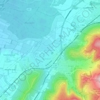
Nom : Carte topographique Wolfenweiler, altitude, relief.
Altitude moyenne : 261 m
Altitude minimum : 209 m
Altitude maximum : 473 m
Faire un don
Équipez-vous pour votre prochaine aventure :
En tant que Partenaire Amazon, ce site perçoit une commission sur les achats éligibles sans surcoût pour vous.
Autres cartes topographiques
Cliquez sur une carte pour visualiser sa topographie, son altitude et son relief.
Bubenbach
Germany > Baden-Württemberg > Landkreis Breisgau-Hochschwarzwald
It lies at an altitude between 800 and 1130m above sea level in the Breg valley.
Altitude moyenne : 988 m
79853
Germany > Baden-Württemberg > Landkreis Breisgau-Hochschwarzwald > Lenzkirch (Kernort)
Altitude moyenne : 895 m
Neustadt im Schwarzwald
Germany > Baden-Württemberg > Landkreis Breisgau-Hochschwarzwald
Altitude moyenne : 943 m
Unadingen
Germany > Baden-Württemberg > Landkreis Breisgau-Hochschwarzwald > Löffingen
Altitude moyenne : 763 m
Faire un don
Équipez-vous pour votre prochaine aventure :
En tant que Partenaire Amazon, ce site perçoit une commission sur les achats éligibles sans surcoût pour vous.
Hartheim am Rhein
Germany > Baden-Württemberg > Landkreis Breisgau-Hochschwarzwald
Altitude moyenne : 206 m
Hinterzarten
Germany > Baden-Württemberg > Landkreis Breisgau-Hochschwarzwald
Altitude moyenne : 987 m
79424
Germany > Baden-Württemberg > Landkreis Breisgau-Hochschwarzwald > Auggen
Altitude moyenne : 260 m
Faire un don
Équipez-vous pour votre prochaine aventure :
En tant que Partenaire Amazon, ce site perçoit une commission sur les achats éligibles sans surcoût pour vous.
Horben
Germany > Baden-Württemberg > Landkreis Breisgau-Hochschwarzwald
Horben is located to the south of the city of Freiburg and east of the Hexental valley on the western slope of the Schauinsland mountain range. It lies between the mountains of "Illenberg" (642 m [2,106 ft]) and "Eduardshöhe" (859 m [2,818 ft]). The area is the source of the Bohrer and Selzenbach creeks.…
Altitude moyenne : 659 m
Altglashütten
Germany > Baden-Württemberg > Landkreis Breisgau-Hochschwarzwald
Feldberg is a municipality in the district of Breisgau-Hochschwarzwald in Baden-Württemberg in southern Germany. It is located near the Feldberg, the highest summit in Baden-Württemberg. It comprises the settlements of Altglashütten, Neuglashütten, Falkau, Bärental, and Feldberg. At an elevation of 1,277…
Altitude moyenne : 1 027 m
Raitenbuch
Germany > Baden-Württemberg > Landkreis Breisgau-Hochschwarzwald > Lenzkirch
Altitude moyenne : 996 m
Faire un don
Équipez-vous pour votre prochaine aventure :
En tant que Partenaire Amazon, ce site perçoit une commission sur les achats éligibles sans surcoût pour vous.
Breisach (Kernstadt)
Germany > Baden-Württemberg > Landkreis Breisgau-Hochschwarzwald > Breisach am Rhein > Hochstetten
Altitude moyenne : 212 m
Faire un don
Équipez-vous pour votre prochaine aventure :
En tant que Partenaire Amazon, ce site perçoit une commission sur les achats éligibles sans surcoût pour vous.
Burkheim
Germany > Baden-Württemberg > Landkreis Breisgau-Hochschwarzwald > Burkheim
Altitude moyenne : 201 m
Faire un don
Équipez-vous pour votre prochaine aventure :
En tant que Partenaire Amazon, ce site perçoit une commission sur les achats éligibles sans surcoût pour vous.
Titisee-Neustadt
Germany > Baden-Württemberg > Landkreis Breisgau-Hochschwarzwald
Altitude moyenne : 972 m
Horben
Germany > Baden-Württemberg > Landkreis Breisgau-Hochschwarzwald
Horben is located to the south of the city of Freiburg and east of the Hexental valley on the western slope of the Schauinsland mountain range. It lies between the mountains of "Illenberg" (642 m [2,106 ft]) and "Eduardshöhe" (859 m [2,818 ft]). The area is the source of the Bohrer and Selzenbach creeks.…
Altitude moyenne : 659 m
Faire un don
Équipez-vous pour votre prochaine aventure :
En tant que Partenaire Amazon, ce site perçoit une commission sur les achats éligibles sans surcoût pour vous.
Lenzkirch
Germany > Baden-Württemberg > Landkreis Breisgau-Hochschwarzwald
Saig is a health resort on the southern flank of the Hochfirst, and at about 1,000m elevation is the highest community in the municipality. It has about 1,200 beds available for tourists.
Altitude moyenne : 945 m
Faire un don
Équipez-vous pour votre prochaine aventure :
En tant que Partenaire Amazon, ce site perçoit une commission sur les achats éligibles sans surcoût pour vous.
Gundelfingen
Germany > Baden-Württemberg > Landkreis Breisgau-Hochschwarzwald > Gundelfingen
Altitude moyenne : 293 m
Münstertal
Germany > Baden-Württemberg > Landkreis Breisgau-Hochschwarzwald
The Münstertal stretches from Staufen im Breisgau up into the Black Forest. It divides into several side valleys and extends in the direction of Belchen(Schwarzwald), via the district of Stohren towards the Schauinsland and via the Münsterhalde towards Badenweiler. The altitude of the Münstertal ranges from…
Altitude moyenne : 643 m
Feldberg
Germany > Baden-Württemberg > Landkreis Breisgau-Hochschwarzwald
Feldberg is a municipality in the district of Breisgau-Hochschwarzwald in Baden-Württemberg in southern Germany. It is located near the Feldberg, the highest summit in Baden-Württemberg. It comprises the settlements of Altglashütten, Neuglashütten, Falkau, Bärental, and Feldberg. At an elevation of 1,277…
Altitude moyenne : 1 037 m
Faire un don
Équipez-vous pour votre prochaine aventure :
En tant que Partenaire Amazon, ce site perçoit une commission sur les achats éligibles sans surcoût pour vous.
Grunern
Germany > Baden-Württemberg > Landkreis Breisgau-Hochschwarzwald > Staufen im Breisgau
Altitude moyenne : 406 m