
Carte topographique Rapa
Carte interactive
Cliquez sur la carte pour afficher l’altitude.
À propos de cette carte
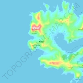
Nom : Carte topographique Rapa, altitude, relief.
Lieu : Rapa, Austral Islands, French Polynesia, France (-27.64998 -144.38136 -27.56647 -144.30470)
Altitude moyenne : 53 m
Altitude minimum : -4 m
Altitude maximum : 573 m
Rapa, also called Rapa Iti, or "Little Rapa", to distinguish it from Easter Island, whose Polynesian name is Rapa Nui, is the largest and only inhabited island of the Bass Islands in French Polynesia. An older name for the island is Oparo. The total land area including offshore islets is 40.5 km2 (15.6 sq mi). As of the 2017 census, Rapa had a population of 507. The island's highest point is at 650 metres (2,130 ft) elevation at Mont Perahu. Its main town is Ahuréi. The inhabitants of Rapa Iti speak their own Polynesian language called the Rapa language.
Autres cartes topographiques
Cliquez sur une carte pour visualiser sa topographie, son altitude et son relief.
Rapa
France > French Polynesia > Rapa
Rapa, Austral Islands, French Polynesia, France
Altitude moyenne : 1 m