Carte topographique Northampton
Carte interactive
Cliquez sur la carte pour afficher l’altitude.
À propos de cette carte
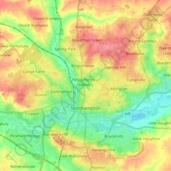
Nom : Carte topographique Northampton, altitude, relief.
Lieu : Northampton, West Northamptonshire, England, United Kingdom (52.21939 -0.95505 52.28270 -0.79137)
Altitude moyenne : 89 m
Altitude minimum : 49 m
Altitude maximum : 135 m
As with the rest of the British Isles, Northampton experiences an oceanic climate with cool summers and mild winters. The official Met Office weather station for Northampton is the Moulton Park Weather Station at the University of Northampton. Situated at an elevation of around 130 m (427 ft) above sea level compared to Northampton town centre at 50 to 60 m (164 to 197 ft), it is one of the highest points in the town, and so may not be a perfect representation of Northampton as a whole. Its hilltop location means less pooling of cold air on calm clear nights, and lower maxima during summer. The absolute maximum recorded is 34.7 °C (94.5 °F) on 3 August 1990. A high of 34.4 °C (93.9 °F) was recorded on 19 July 2006, However, a maximum temperature of 40.2 °C (104.4 °F) was recorded on 19 July 2022 at Pitsford, located 4.4 miles (7.1 km) from the town centre. The absolute minimum is −16.8 °C (1.8 °F), recorded during February 1986. It is likely the absolute maximum in the town centre is a degree or so higher owing to the lower elevation, and absolute minimum on the eastern and western edges of the urban area around the Nene valley a couple of degrees colder due to katabatic drainage of cold air allowing a frost hollow effect. Most recently, the temperature fell to −9.6 °C (14.7 °F) on 20 December 2010.
Autres cartes topographiques
Cliquez sur une carte pour visualiser sa topographie, son altitude et son relief.
Northampton
United Kingdom > England > West Northamptonshire > Northampton
Northampton, West Northamptonshire, England, United Kingdom
Altitude moyenne : 89 m
Cold Higham
United Kingdom > England > West Northamptonshire
Cold Higham, West Northamptonshire, England, United Kingdom
Altitude moyenne : 131 m
Long Buckby Wharf
United Kingdom > England > West Northamptonshire
Long Buckby Wharf, Long Buckby, West Northamptonshire, England, NN6 7PP, United Kingdom
Altitude moyenne : 114 m
Fosters Booth
United Kingdom > England > West Northamptonshire
Fosters Booth, Pattishall, West Northamptonshire, England, NN12 8LB, United Kingdom
Altitude moyenne : 128 m
Yardley Hastings
United Kingdom > England > West Northamptonshire
Yardley Hastings, West Northamptonshire, England, United Kingdom
Altitude moyenne : 94 m
Spratton
United Kingdom > England > West Northamptonshire
Spratton, West Northamptonshire, England, United Kingdom
Altitude moyenne : 98 m
Litchborough
United Kingdom > England > West Northamptonshire
Litchborough, West Northamptonshire, England, United Kingdom
Altitude moyenne : 142 m
Upton Country Park
United Kingdom > England > West Northamptonshire > Harpole
Upton Country Park, Upton, Harpole, West Northamptonshire, England, United Kingdom
Altitude moyenne : 75 m
Castle Ashby
United Kingdom > England > West Northamptonshire
Castle Ashby, West Northamptonshire, England, NN7 1LF, United Kingdom
Altitude moyenne : 71 m
Lower Thorpe
United Kingdom > England > West Northamptonshire > Thorpe Mandeville
Lower Thorpe, Thorpe Mandeville, West Northamptonshire, England, OX17 2HP, United Kingdom
Altitude moyenne : 154 m
Maidford
United Kingdom > England > West Northamptonshire
Maidford, West Northamptonshire, England, United Kingdom
Altitude moyenne : 157 m
Onley
United Kingdom > England > West Northamptonshire
Onley, West Northamptonshire, England, CV23 8AW, United Kingdom
Altitude moyenne : 99 m
Stoke Bruerne
United Kingdom > England > West Northamptonshire
Stoke Bruerne, West Northamptonshire, England, NN12 7SD, United Kingdom
Altitude moyenne : 98 m
Pitsford Water
United Kingdom > England > West Northamptonshire > Pitsford
Pitsford Water, Pitsford, West Northamptonshire, England, United Kingdom
Altitude moyenne : 108 m
Nether Heyford
United Kingdom > England > West Northamptonshire
Nether Heyford, West Northamptonshire, England, United Kingdom
Altitude moyenne : 91 m
Great Brington
United Kingdom > England > West Northamptonshire
Great Brington, West Northamptonshire, England, NN7 4JD, United Kingdom
Altitude moyenne : 118 m
Foxley
United Kingdom > England > West Northamptonshire > Blakesley
Foxley, Blakesley, West Northamptonshire, England, NN12 8HP, United Kingdom
Altitude moyenne : 139 m
Sibbertoft
United Kingdom > England > West Northamptonshire > Sibbertoft
Sibbertoft, West Northamptonshire, England, United Kingdom
Altitude moyenne : 156 m
Thenford
United Kingdom > England > West Northamptonshire
Thenford, West Northamptonshire, England, United Kingdom
Altitude moyenne : 134 m
Braunston
United Kingdom > England > West Northamptonshire > Braunston
Braunston, West Northamptonshire, England, United Kingdom
Altitude moyenne : 128 m
Blakesley
United Kingdom > England > West Northamptonshire
Blakesley, West Northamptonshire, England, United Kingdom
Altitude moyenne : 141 m
Creaton
United Kingdom > England > West Northamptonshire > Great Creaton
Creaton, Great Creaton, West Northamptonshire, England, United Kingdom
Altitude moyenne : 106 m
Watford Gap
United Kingdom > England > West Northamptonshire
Watford Gap, Watford, West Northamptonshire, England, NN6 7UH, United Kingdom
Altitude moyenne : 139 m
Draughton
United Kingdom > England > West Northamptonshire
Draughton, West Northamptonshire, England, United Kingdom
Altitude moyenne : 140 m
Silverstone
United Kingdom > England > West Northamptonshire
Silverstone, West Northamptonshire, England, United Kingdom
Altitude moyenne : 133 m
Tiffield
United Kingdom > England > West Northamptonshire
Tiffield, West Northamptonshire, England, NN12 8AB, United Kingdom
Altitude moyenne : 122 m
Brockhall
United Kingdom > England > West Northamptonshire
Brockhall, West Northamptonshire, England, United Kingdom
Altitude moyenne : 105 m
Kelmarsh
United Kingdom > England > West Northamptonshire
Kelmarsh, West Northamptonshire, England, United Kingdom
Altitude moyenne : 138 m
Hunsbury Hill
United Kingdom > England > West Northamptonshire > Far Cotton
Hunsbury Hill, Far Cotton, West Northamptonshire, England, NN4 9RR, United Kingdom
Altitude moyenne : 79 m
Harlestone
United Kingdom > England > West Northamptonshire
Harlestone, West Northamptonshire, England, United Kingdom
Altitude moyenne : 102 m
Croughton
United Kingdom > England > West Northamptonshire
Croughton, West Northamptonshire, England, United Kingdom
Altitude moyenne : 127 m
Barby
United Kingdom > England > West Northamptonshire
Barby, West Northamptonshire, England, United Kingdom
Altitude moyenne : 114 m
Old Mill Race
United Kingdom > England > West Northamptonshire > Whilton
Old Mill Race, Norton, Whilton, West Northamptonshire, England, NN7 4JZ, United Kingdom
Altitude moyenne : 109 m
Pattishall
United Kingdom > England > West Northamptonshire
Pattishall, West Northamptonshire, England, United Kingdom
Altitude moyenne : 125 m
Ladybridge Park
United Kingdom > England > West Northamptonshire
Ladybridge Park, West Hunsbury, West Northamptonshire, England, United Kingdom
Altitude moyenne : 81 m
Bradden
United Kingdom > England > West Northamptonshire
Bradden, West Northamptonshire, England, United Kingdom
Altitude moyenne : 118 m
Whitfield
United Kingdom > England > West Northamptonshire
Whitfield, West Northamptonshire, England, United Kingdom
Altitude moyenne : 128 m
Duston
United Kingdom > England > West Northamptonshire > Duston
Duston, West Northamptonshire, England, United Kingdom
Altitude moyenne : 97 m
Puxley
United Kingdom > England > West Northamptonshire
Puxley, Deanshanger, West Northamptonshire, England, NN12 7QS, United Kingdom
Altitude moyenne : 95 m
Sulgrave
United Kingdom > England > West Northamptonshire
Sulgrave, West Northamptonshire, England, United Kingdom
Altitude moyenne : 157 m
Honey Hill
United Kingdom > England > West Northamptonshire
Honey Hill, West Northamptonshire, England, NN6 6NL, United Kingdom
Altitude moyenne : 169 m
Edgcote
United Kingdom > England > West Northamptonshire > Chipping Warden
Edgcote, Chipping Warden and Edgcote, Chipping Warden, West Northamptonshire, England, OX17 1AG, United Kingdom
Altitude moyenne : 133 m
Preston Capes
United Kingdom > England > West Northamptonshire
Preston Capes, West Northamptonshire, England, United Kingdom
Altitude moyenne : 156 m
Middleton Cheney
United Kingdom > England > West Northamptonshire
Middleton Cheney, West Northamptonshire, England, United Kingdom
Altitude moyenne : 128 m
Moreton Pinkney
United Kingdom > England > West Northamptonshire
Moreton Pinkney, West Northamptonshire, England, United Kingdom
Altitude moyenne : 151 m
Overstone
United Kingdom > England > West Northamptonshire
Overstone, West Northamptonshire, England, United Kingdom
Altitude moyenne : 109 m
Upper Stowe
United Kingdom > England > West Northamptonshire > Upper Stowe
Upper Stowe, West Northamptonshire, England, NN7 4SL, United Kingdom
Altitude moyenne : 115 m
Kingsthorpe
United Kingdom > England > West Northamptonshire
Kingsthorpe, West Northamptonshire, England, United Kingdom
Altitude moyenne : 95 m
East Hunsbury
United Kingdom > England > West Northamptonshire
East Hunsbury, West Northamptonshire, England, United Kingdom
Altitude moyenne : 87 m
Hellidon
United Kingdom > England > West Northamptonshire
Hellidon, West Northamptonshire, England, United Kingdom
Altitude moyenne : 159 m