
Carte topographique Andros Island
Carte interactive
Cliquez sur la carte pour afficher l’altitude.
À propos de cette carte
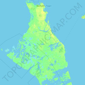
Nom : Carte topographique Andros Island, altitude, relief.
Lieu : Andros Island, The Bahamas (24.26893 -78.46197 25.20498 -77.71598)
Altitude moyenne : 1 m
Altitude minimum : -6 m
Altitude maximum : 23 m
Autres cartes topographiques
Cliquez sur une carte pour visualiser sa topographie, son altitude et son relief.
Stanleyville
Stanleyville, New Providence, The Bahamas
Altitude moyenne : 7 m
Harbour Island
Harbour Island, Dunmore Town, Harbour Island, The Bahamas
Altitude moyenne : 1 m
Rose Island
Rose Island, Nassau, New Providence, The Bahamas
Altitude moyenne : 0 m
Williams Island
Williams Island, North Andros, The Bahamas
Altitude moyenne : 0 m
Highbury Park
Highbury Park, New Providence, The Bahamas
Altitude moyenne : 7 m
Grand Bahama
The Bahamas > East Grand Bahama
Grand Bahama, East Grand Bahama, The Bahamas
Altitude moyenne : 1 m
Russell Island
Russell Island, Spanish Wells, The Bahamas
Altitude moyenne : 1 m
Bimini
The Bahamas > Bimini > Bailey Town
Bimini, Bailey Town, Bimini, The Bahamas
Altitude moyenne : 1 m
Charlotteville
Charlotteville, New Providence, The Bahamas
Altitude moyenne : 5 m
Little Whale Cay
The Bahamas > West Grand Bahama
Little Whale Cay, West Grand Bahama, The Bahamas
Altitude moyenne : 0 m