
Carte topographique Middle Creek
Carte interactive
Cliquez sur la carte pour afficher l’altitude.
À propos de cette carte
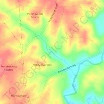
Nom : Carte topographique Middle Creek, altitude, relief.
Altitude moyenne : 157 m
Altitude minimum : 111 m
Altitude maximum : 192 m
Autres cartes topographiques
Cliquez sur une carte pour visualiser sa topographie, son altitude et son relief.
Queen Anne's County
United States of America > Maryland
Queen Anne's County, Maryland, United States of America
Altitude moyenne : 10 m
Forest Manor
United States of America > Maryland > Forest Manor
Forest Manor, Forestville, Prince George's County, Maryland, 20747, United States of America
Altitude moyenne : 80 m
College Park
United States of America > Maryland > College Park > College Park
College Park, Prince George's County, Maryland, United States of America
Altitude moyenne : 38 m