
Carte topographique Middletown
Carte interactive
Cliquez sur la carte pour afficher l’altitude.
À propos de cette carte
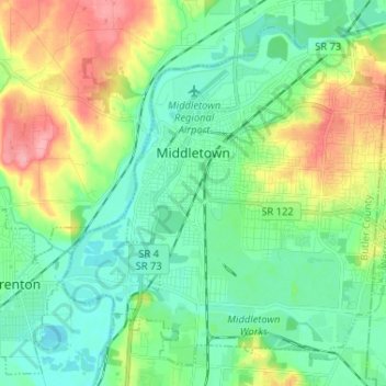
Nom : Carte topographique Middletown, altitude, relief.
Lieu : Middletown, Butler County, Ohio, United States (39.45981 -84.42224 39.54903 -84.29252)
Altitude moyenne : 216 m
Altitude minimum : 185 m
Altitude maximum : 287 m
Autres cartes topographiques
Cliquez sur une carte pour visualiser sa topographie, son altitude et son relief.
Wetherington
United States > Ohio > Butler County > Wetherington
Wetherington, West Chester Township, Butler County, Ohio, United States
Altitude moyenne : 261 m
Oxford
United States > Ohio > Butler County
Oxford, Oxford Township, Butler County, Ohio, 45056, United States
Altitude moyenne : 279 m
West Chester Township
United States > Ohio > Butler County
West Chester Township, Butler County, Ohio, 45069, United States
Altitude moyenne : 230 m
Astoria
United States > Ohio > Butler County
Astoria, Madison Township, Butler County, Ohio, United States
Altitude moyenne : 263 m
Olde West Chester
United States > Ohio > Butler County
Olde West Chester, West Chester Township, Butler County, Ohio, United States
Altitude moyenne : 227 m
West Chester
United States > Ohio > Butler County > West Chester
West Chester, West Chester Township, Butler County, Ohio, 45069, United States
Altitude moyenne : 231 m