
Carte topographique Argentera
Carte interactive
Cliquez sur la carte pour afficher l’altitude.
À propos de cette carte
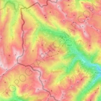
Nom : Carte topographique Argentera, altitude, relief.
Lieu : Argentera, Cuneo, Piedmont, Italy (44.31929 6.88701 44.42996 7.03051)
Altitude moyenne : 2 195 m
Altitude minimum : 1 245 m
Altitude maximum : 2 935 m
Argentera borders the following municipalities: Acceglio, Canosio, Larche (France), Pietraporzio, and Saint-Etienne-de-Tinée (France). Its territory includes peaks such as the Oserot at an elevation of 2,860 metres (9,380 ft) above sea level, Enciastraia at 2,955 metres (9,695 ft) and the Rocca dei Tre Vescovi at 2,867 metres (9,406 ft).
Autres cartes topographiques
Cliquez sur une carte pour visualiser sa topographie, son altitude et son relief.
Bersia
Italy > Piedmont > Cuneo > San Damiano Macra
Bersia, San Damiano Macra, Cuneo, Piedmont, 12020, Italy
Altitude moyenne : 1 336 m
Fre
Italy > Piedmont > Cuneo > Montemale di Cuneo
Fre, Montemale di Cuneo, Cuneo, Piedmont, Italy
Altitude moyenne : 997 m
Giardino Famiglia Allemandi
Italy > Piedmont > Cuneo > Villar San Costanzo > Pramallé
Giardino Famiglia Allemandi, Pramallé, Villar San Costanzo, Cuneo, Piedmont, Italy
Altitude moyenne : 654 m
Punta Razil
Italy > Piedmont > Cuneo > Bagnolo Piemonte
Punta Razil, Bagnolo Piemonte, Cuneo, Piedmont, Italy
Altitude moyenne : 2 008 m
Pontechianale
Pontechianale, Cuneo, Piedmont, Italy
Altitude moyenne : 2 447 m
Limone Piemonte
Limone Piemonte, Cuneo, Piedmont, 12015, Italy
Altitude moyenne : 1 619 m