
Carte topographique Drensteinfurt
Carte interactive
Cliquez sur la carte pour afficher l’altitude.
À propos de cette carte
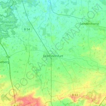
Nom : Carte topographique Drensteinfurt, altitude, relief.
Altitude moyenne : 69 m
Altitude minimum : 53 m
Altitude maximum : 117 m
Autres cartes topographiques
Cliquez sur une carte pour visualiser sa topographie, son altitude et son relief.
Sendenhorst
Deutschland > Nordrhein-Westfalen > Kreis Warendorf
Sendenhorst, Kreis Warendorf, Nordrhein-Westfalen, 48324, Deutschland
Altitude moyenne : 64 m
Freckenhorst
Deutschland > Nordrhein-Westfalen > Kreis Warendorf > Warendorf
Freckenhorst, Warendorf, Kreis Warendorf, Nordrhein-Westfalen, Deutschland
Altitude moyenne : 66 m
Everswinkel
Deutschland > Nordrhein-Westfalen > Kreis Warendorf
Everswinkel, Kreis Warendorf, Nordrhein-Westfalen, 48351, Deutschland
Altitude moyenne : 61 m
Beelen
Deutschland > Nordrhein-Westfalen > Kreis Warendorf
Beelen, Kreis Warendorf, Nordrhein-Westfalen, 48361, Deutschland
Altitude moyenne : 63 m
Rinkerode
Deutschland > Nordrhein-Westfalen > Kreis Warendorf > Drensteinfurt
Rinkerode, Drensteinfurt, Kreis Warendorf, Nordrhein-Westfalen, Deutschland
Altitude moyenne : 60 m
Warendorf
Deutschland > Nordrhein-Westfalen > Kreis Warendorf
Warendorf, Kreis Warendorf, Nordrhein-Westfalen, 48231, Deutschland
Altitude moyenne : 64 m
Haus Heidhorn
Deutschland > Nordrhein-Westfalen > Kreis Warendorf > Drensteinfurt
Haus Heidhorn, Münster-Hiltrup, Drensteinfurt, Kreis Warendorf, Nordrhein-Westfalen, 48163, Deutschland
Altitude moyenne : 59 m
Hornheide
Deutschland > Nordrhein-Westfalen > Kreis Warendorf > Telgte
Hornheide, Telgte, Kreis Warendorf, Nordrhein-Westfalen, 48291, Deutschland
Altitude moyenne : 55 m
Ennigerloh
Deutschland > Nordrhein-Westfalen > Kreis Warendorf
Ennigerloh, Kreis Warendorf, Nordrhein-Westfalen, 59320, Deutschland
Altitude moyenne : 82 m
Ahlen
Deutschland > Nordrhein-Westfalen > Kreis Warendorf
Ahlen, Kreis Warendorf, Nordrhein-Westfalen, Deutschland
Altitude moyenne : 81 m
Beckum
Deutschland > Nordrhein-Westfalen > Kreis Warendorf
Beckum, Kreis Warendorf, Nordrhein-Westfalen, 59269, Deutschland
Altitude moyenne : 110 m