
Carte topographique Sölden
Carte interactive
Cliquez sur la carte pour afficher l’altitude.
À propos de cette carte
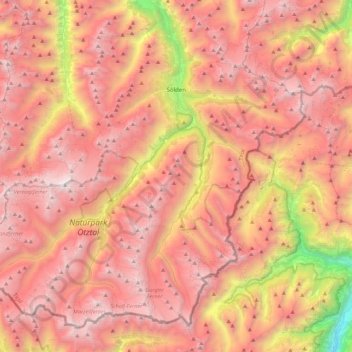
Nom : Carte topographique Sölden, altitude, relief.
Lieu : Sölden, Bezirk Imst, Tyrol, Austria (46.76285 10.72601 47.02239 11.16810)
Altitude moyenne : 2 483 m
Altitude minimum : 499 m
Altitude maximum : 3 721 m
The main village of Sölden is at an elevation of 1,368 metres (4,488 ft) above sea level, and the upper village of Hochsölden at 2,090 m (6,857 ft) has 5 four-star hotels. The highest peak is the Wildspitze, at 3,768 m (12,362 ft), the second highest mountain in Austria, after the Großglockner.
Autres cartes topographiques
Cliquez sur une carte pour visualiser sa topographie, son altitude et son relief.
Gemeinde Silz
Austria > Tyrol > Bezirk Imst
Gemeinde Silz, Bezirk Imst, Tyrol, Austria
Altitude moyenne : 1 994 m
Martin-Busch-Hütte
Austria > Tyrol > Bezirk Imst > Gemeinde Sölden
Martin-Busch-Hütte, 403, Hütten Vent, Gemeinde Sölden, Bezirk Imst, Tyrol, 6458, Austria
Altitude moyenne : 2 681 m