
Carte topographique Richfield
Carte interactive
Cliquez sur la carte pour afficher l’altitude.
À propos de cette carte
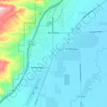
Nom : Carte topographique Richfield, altitude, relief.
Lieu : Richfield, Sevier County, Utah, United States (38.72436 -112.11753 38.79362 -112.06645)
Altitude moyenne : 1 659 m
Altitude minimum : 1 599 m
Altitude maximum : 2 033 m
Richfield experiences a cold semi-arid climate (Köppen BSk) with four distinct seasons. Winter high temperatures average in the 30s and 40s with many milder days; low temperatures average in the teens and twenties, with a few mornings starting near or below zero. Snowfall is common, but usually melts in a day or two; however, deeper lasting snow cover is not uncommon. Still, December and January average among Richfield’s drier months. Summer days are warm, with normal July highs in the 90s and occasional hot spells that near 100 °F or 37.8 °C. Nighttime temperatures during the summer are comfortable—usually in the 50s or 60s. From July through September, “monsoonal” thunderstorms frequently form over the nearby peaks contributing to over a third of the 8.12 inches or 206.2 millimetres of annual rainfall. Because of its low humidity and mile-high altitude, the Sevier Valley experiences its average first frost by late September and its last in late May, despite the typically warm fall and spring days. Richfield’s record high is 104 °F (40 °C), set on July 23, 1931 and July 13-14, 1939, and the record low is −33 °F (−36.1 °C), set on February 6, 1989.
Autres cartes topographiques
Cliquez sur une carte pour visualiser sa topographie, son altitude et son relief.
Salina
United States > Utah > Sevier County
Salina, Sevier County, Utah, 84654, United States
Altitude moyenne : 1 637 m
Monroe
United States > Utah > Sevier County
Monroe, Sevier County, Utah, 84754, United States
Altitude moyenne : 1 678 m