
Carte topographique Selwyn District
Carte interactive
Cliquez sur la carte pour afficher l’altitude.
À propos de cette carte
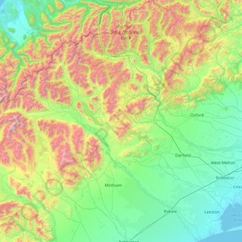
Nom : Carte topographique Selwyn District, altitude, relief.
Lieu : Selwyn District, Canterbury, New Zealand (-43.90397 171.11351 -42.74080 172.62777)
Altitude moyenne : 679 m
Altitude minimum : -1 m
Altitude maximum : 2 745 m
Autres cartes topographiques
Cliquez sur une carte pour visualiser sa topographie, son altitude et son relief.
Earthquakes
New Zealand > Canterbury > Waitaki District
Earthquakes, Waitaki District, Canterbury, New Zealand
Altitude moyenne : 237 m
Halswell-Hornby-Riccarton Community
New Zealand > Canterbury > Christchurch City
Halswell-Hornby-Riccarton Community, Christchurch City, Canterbury, New Zealand
Altitude moyenne : 49 m
Lincoln
New Zealand > Canterbury > Selwyn District > Lincoln
Lincoln, Selwyn District, Canterbury, 7608, New Zealand
Altitude moyenne : 15 m
Lyttelton
New Zealand > Canterbury > Lyttelton
Lyttelton, Christchurch City, Canterbury, 8082, New Zealand
Altitude moyenne : 99 m
Mount Wilson
Mount Wilson, Selwyn District, Canterbury, New Zealand
Altitude moyenne : 1 569 m
Lyttelton
New Zealand > Canterbury > Lyttelton
Lyttelton, Christchurch City, Canterbury, 8082, New Zealand
Altitude moyenne : 105 m
Dennistoun Glacier
Dennistoun Glacier, Mackenzie District, Canterbury, New Zealand
Altitude moyenne : 2 026 m
Ball Glacier
Ball Glacier, Caroline hut to ball hut, Mackenzie District, Canterbury, New Zealand
Altitude moyenne : 1 324 m
Mount Hutt
Mount Hutt, Ashburton District, Canterbury, New Zealand
Altitude moyenne : 1 732 m
Maud Glacier
Maud Glacier, Mackenzie District, Canterbury, New Zealand
Altitude moyenne : 1 711 m
Mount Dampier
Mount Dampier, Mackenzie District, Canterbury, New Zealand
Altitude moyenne : 2 847 m
Mount Cook
Mount Cook, Mackenzie District, Canterbury, New Zealand
Altitude moyenne : 2 920 m
Anna Glacier
Anna Glacier, Mackenzie District, Canterbury, New Zealand
Altitude moyenne : 2 446 m
Mueller Glacier
New Zealand > Canterbury > Mount Cook Village
Mueller Glacier, Mueller Hut Route, Mount Cook Village, Mackenzie District, Canterbury, 7946, New Zealand
Altitude moyenne : 1 616 m
Te Hīwai / Murchison Glacier
Te Hīwai / Murchison Glacier, Mackenzie District, Canterbury, New Zealand
Altitude moyenne : 1 875 m
Southern Alps
Southern Alps, Mackenzie District, Canterbury, New Zealand
Altitude moyenne : 2 832 m
Cascade Glacier
Cascade Glacier, Mackenzie District, Canterbury, New Zealand
Altitude moyenne : 2 106 m
Christchurch City
Christchurch City, Canterbury, New Zealand
Altitude moyenne : 74 m
Godley Glacier
Godley Glacier, Mackenzie District, Canterbury, New Zealand
Altitude moyenne : 1 579 m
South Island
South Island, Ashburton District, Canterbury, New Zealand
Altitude moyenne : 201 m
Mount Vancouver
Mount Vancouver, Mackenzie District, Canterbury, New Zealand
Altitude moyenne : 2 804 m