
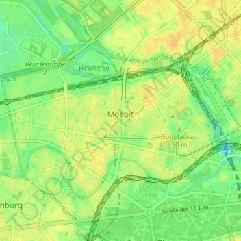
Carte topographique Moabit
Cliquez sur la carte pour afficher l’altitude.
À propos de cette carte
Nom : Carte topographique Moabit, altitude, relief.
Lieu : Moabit, Mitte, Berlin, Germany (52.51667 13.31143 52.54143 13.37386)
Altitude moyenne : 39 m
Altitude minimum : 25 m
Altitude maximum : 48 m
Autres cartes topographiques
Cliquez sur une carte pour visualiser sa topographie, son altitude et son relief.
Teufelsberg
Teufelsberg was originally thought to be 115 metres (377 ft) high, which placed it at the same elevation as Großer Müggelberg (the summit of Müggelberge), and was the highest point in West Berlin. New measurements show that Teufelsberg is actually 120.1 metres (394 ft) high, making it higher than Großer…
Altitude moyenne : 54 m
Viktoriapark
On the occasion of the elevation of the monument ideas appeared to lay out a park around it. Two years later the design of a park was put out to tender. Hermann Mächtig (*1837-1909*), since 1877 Berlin's city garden director, handed in a design, already using the name Victoria Park, in honour of Princess…
Altitude moyenne : 45 m