
Carte topographique Thuringian Forest
Carte interactive
Cliquez sur la carte pour afficher l’altitude.
À propos de cette carte
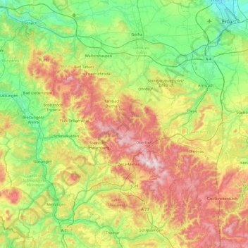
Nom : Carte topographique Thuringian Forest, altitude, relief.
Altitude moyenne : 447 m
Altitude minimum : 173 m
Altitude maximum : 975 m
The Thuringian Forest forms a continuous chain of ancient rounded mountains with steep slopes to both sides and poses ample difficulties in transit routing save through a few navigable passes. It is about 70 km (43 mi) long and 20 km (12 mi) wide. The highest elevation is Großer Beerberg at 982 m (3,222 ft) a.s.l.