
Carte topographique Cianciana
Carte interactive
Cliquez sur la carte pour afficher l’altitude.
À propos de cette carte
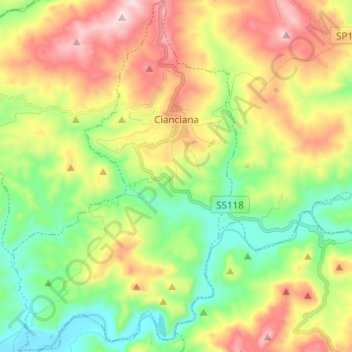
Nom : Carte topographique Cianciana, altitude, relief.
Lieu : Cianciana, Agrigento, Sicily, 92012, Italy (37.45536 13.37639 37.55272 13.45511)
Altitude moyenne : 267 m
Altitude minimum : 24 m
Altitude maximum : 627 m
Cianciana is a comune (municipality) in the Province of Agrigento in the Italian region Sicily, located in the middle valley of the Platani river, about 70 kilometres (43 mi) south of Palermo and about 25 kilometres (16 mi) northwest of Agrigento. The Monte Cammarata, elevation 1,579 metres (5,180 ft) above sea level, part of the Monti Sicani chain, is nearby.