
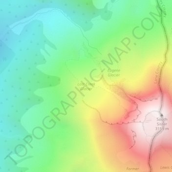
Carte topographique Lost Creek Glacier
Carte interactive
Cliquez sur la carte pour afficher l’altitude.
À propos de cette carte
Nom : Carte topographique Lost Creek Glacier, altitude, relief.
Altitude moyenne : 2 430 m
Altitude minimum : 1 995 m
Altitude maximum : 3 139 m
Autres cartes topographiques
Cliquez sur une carte pour visualiser sa topographie, son altitude et son relief.
Forest Park
Forest Park, Maple Trail, Forest Park, Portland, Multnomah County, Oregon, 97203, USA
Altitude moyenne : 91 m
Cascade Locks
USA > Oregon > Cascade Locks
Cascade Locks, Hood River County, Oregon, USA
Altitude moyenne : 101 m
Jefferson Park Glacier
Jefferson Park Glacier, Pacific Crest Trail, Jefferson County, Oregon, USA
Altitude moyenne : 2 421 m
Crook Glacier
Crook Glacier, Broken Top NW Ridge route, Deschutes County, Oregon, USA
Altitude moyenne : 2 347 m
Langille Glacier
Langille Glacier, Eliot west moraine, Hood River County, Oregon, USA
Altitude moyenne : 2 165 m
Thayer Glacier
Thayer Glacier, climber's trail, Deschutes County, Oregon, USA
Altitude moyenne : 2 423 m
Milk Creek Glacier
Milk Creek Glacier, Pacific Crest Trail, Jefferson County, Oregon, USA
Altitude moyenne : 2 508 m
Zigzag Glacier
Zigzag Glacier, Mountaineer Trail #798, Clackamas County, Oregon, USA
Altitude moyenne : 2 620 m
Irving Glacier
Irving Glacier, Camp Lake Trail, Deschutes County, Oregon, USA
Altitude moyenne : 2 344 m
Lathrop Glacier
Lathrop Glacier, Mt. Thielsen climber's trail, Douglas County, Oregon, USA
Altitude moyenne : 2 235 m
Clark Glacier
Clark Glacier, South Sister Climber Trail #36, Deschutes County, Oregon, USA
Altitude moyenne : 2 578 m
White River Glacier
White River Glacier, Mountaineer Trail #798, Clackamas County, Oregon, USA
Altitude moyenne : 2 523 m
Michael Harding Park
USA > Oregon > Falls City
Michael Harding Park, Falls City, Polk County, Oregon, 97344, USA
Altitude moyenne : 176 m
Pinnacle Reservoir
Pinnacle Reservoir, Three Fingers Gulch Road, Malheur County, Oregon, USA
Altitude moyenne : 1 193 m
Skinner Glacier
Skinner Glacier, South Sister Climber Trail #36, Deschutes County, Oregon, USA
Altitude moyenne : 2 480 m
Coe Glacier
Coe Glacier, Barrett Spur, Hood River County, Oregon, USA
Altitude moyenne : 2 328 m
Linn Glacier
Linn Glacier, Pacific Crest Trail, Deschutes County, Oregon, USA
Altitude moyenne : 2 359 m
Carver Glacier
Carver Glacier, South Sister Climber Trail #36, Deschutes County, Oregon, USA
Altitude moyenne : 2 385 m
Villard Glacier
Villard Glacier, climber's trail, Deschutes County, Oregon, USA
Altitude moyenne : 2 448 m
Coalman Glacier
Coalman Glacier, Cooper Spur Trail #600B, Hood River County, Oregon, USA
Altitude moyenne : 2 728 m
Newton Clark Glacier
Newton Clark Glacier, Cooper Spur Trail #600B, Hood River County, Oregon, USA
Altitude moyenne : 2 589 m
Wallowa Mountains
Wallowa Mountains, Wallowa County, Oregon, USA
Altitude moyenne : 2 475 m
Collier Glacier
Collier Glacier, climber's trail, Deschutes County, Oregon, USA
Altitude moyenne : 2 549 m
Hosford-Abernethy
Hosford-Abernethy, Portland, Multnomah County, Oregon, USA
Altitude moyenne : 26 m
Waldo Glacier
Waldo Glacier, Pacific Crest Trail, Jefferson County, Oregon, USA
Altitude moyenne : 2 352 m
Sandy Glacier
Sandy Glacier, Yocum Ridge Trail #771, Clackamas County, Oregon, USA
Altitude moyenne : 2 365 m
Prouty Glacier
Prouty Glacier, South Sister Climber Trail #36, Deschutes County, Oregon, USA
Altitude moyenne : 2 589 m
Palmer Glacier
Palmer Glacier, Mountaineer Trail #798, Clackamas County, Oregon, USA
Altitude moyenne : 2 424 m
Glisan Glacier
Glisan Glacier, McNeil Point Trail #600M, Hood River County, Oregon, USA
Altitude moyenne : 2 086 m
Diller Glacier
Diller Glacier, climber's trail, Deschutes County, Oregon, USA
Altitude moyenne : 2 416 m
Renfrew Glacier
Renfrew Glacier, climber's trail, Deschutes County, Oregon, USA
Altitude moyenne : 2 538 m
Eliot Glacier
Eliot Glacier, Eliot west moraine, Hood River County, Oregon, USA
Altitude moyenne : 2 316 m
Reid Glacier
Reid Glacier, Yocum Ridge Trail #771, Clackamas County, Oregon, USA
Altitude moyenne : 2 410 m