
Faire un don
Équipez-vous pour votre prochaine aventure :
En tant que Partenaire Amazon, ce site perçoit une commission sur les achats éligibles sans surcoût pour vous.
Carte topographique Independence Pass
Cliquez sur la carte pour afficher l’altitude.
Faire un don
Équipez-vous pour votre prochaine aventure :
En tant que Partenaire Amazon, ce site perçoit une commission sur les achats éligibles sans surcoût pour vous.
Independence Pass
Independence Pass, originally known as Hunter Pass, is a high mountain pass in central Colorado, United States. It is at elevation 12,095 ft (3,687 m) on the Continental Divide in the Sawatch Range of the Rocky Mountains. The pass is midway between Aspen and Twin Lakes, on the border between Pitkin and Lake counties.
Faire un don
Équipez-vous pour votre prochaine aventure :
En tant que Partenaire Amazon, ce site perçoit une commission sur les achats éligibles sans surcoût pour vous.
À propos de cette carte
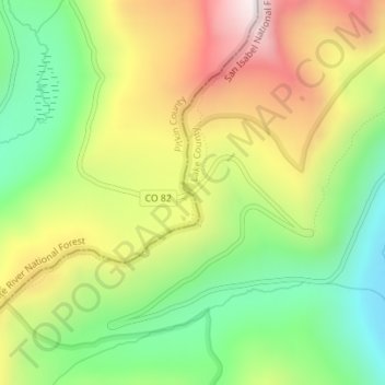
Nom : Carte topographique Independence Pass, altitude, relief.
Lieu : Independence Pass, Lake County, Colorado, United States (39.10853 -106.56404 39.10863 -106.56394)
Altitude moyenne : 3 627 m
Altitude minimum : 3 258 m
Altitude maximum : 4 091 m
Faire un don
Équipez-vous pour votre prochaine aventure :
En tant que Partenaire Amazon, ce site perçoit une commission sur les achats éligibles sans surcoût pour vous.
Autres cartes topographiques
Cliquez sur une carte pour visualiser sa topographie, son altitude et son relief.
Leadville
United States > Colorado > Lake County
The City of Leadville is a statutory city that is the county seat, the most populous community, and the only incorporated municipality in Lake County, Colorado, United States. The city population was 2,602 at the 2010 census and an estimated 2,762 in 2018. It is situated at an elevation of 10,152 feet (3,094…
Altitude moyenne : 3 107 m
Mount Massive Wilderness
United States > Colorado > Lake County
The Mount Massive Wilderness is a federally designated wilderness area in the Sawatch Range, located in the U.S. state of Colorado. It is operated jointly by the United States Forest Service and the Fish and Wildlife Service as part of the San Isabel National Forest and the Leadville National Fish Hatchery. It…
Altitude moyenne : 3 432 m
Leadville
United States > Colorado > Lake County
The City of Leadville is a statutory city that is the county seat, the most populous community, and the only incorporated municipality in Lake County, Colorado, United States. The city population was 2,602 at the 2010 census and an estimated 2,762 in 2018. It is situated at an elevation of 10,152 feet (3,094…
Altitude moyenne : 3 107 m
Faire un don
Équipez-vous pour votre prochaine aventure :
En tant que Partenaire Amazon, ce site perçoit une commission sur les achats éligibles sans surcoût pour vous.