
Carte topographique Carnaza
Carte interactive
Cliquez sur la carte pour afficher l’altitude.
À propos de cette carte
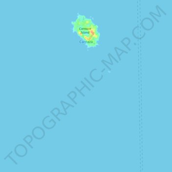
Nom : Carte topographique Carnaza, altitude, relief.
Lieu : Carnaza, Cebu, Central Visayas, Philippines (11.44561 124.01932 11.52465 124.11175)
Altitude moyenne : 0 m
Altitude minimum : 0 m
Altitude maximum : 36 m
The island's topography includes coastal plains, mangrove swamps, lagoons and semi-rounded hills. Its coastal plain constitutes about 9.7% while semi-rounded hills constitute the biggest portion of the island covering about 14.4% of the total area. The mangrove forest has an area of about 10.1 hectares or 5.8% of the island. The highest point was measured at 55 metres (180 feet) above sea level.
Autres cartes topographiques
Cliquez sur une carte pour visualiser sa topographie, son altitude et son relief.
Cebu City
Philippines > Cebu > Cebu City
Cebu City, Cebu, Central Visayas, 6000, Philippines
Altitude moyenne : 140 m
Pinamungajan
Pinamungajan, Cebu, Central Visayas, 6039, Philippines
Altitude moyenne : 35 m
Damolog
Philippines > Cebu > Sogod
Damolog, Sogod, Cebu, Central Visayas, 6007, Philippines
Altitude moyenne : 70 m
Basak
Philippines > Cebu > Badian
Basak, Badian, Cebu, Central Visayas, 6031, Philippines
Altitude moyenne : 305 m
Yati
Philippines > Cebu > Liloan
Yati, Liloan, Cebu, Central Visayas, 6002, Philippines
Altitude moyenne : 14 m
Caurasan
Philippines > Cebu > Carmen
Caurasan, Carmen, Cebu, Central Visayas, Philippines
Altitude moyenne : 531 m
Dawis Sur
Dawis Sur, Cebu, Central Visayas, 6005, Philippines
Altitude moyenne : 20 m
Bantayan Island
Philippines > Cebu > Sungko
Bantayan Island, Sungko, Cebu, Central Visayas, Philippines
Altitude moyenne : 5 m
Cogon
Philippines > Cebu > Cordova
Cogon, Cordova, Cebu, Central Visayas, 6017, Philippines
Altitude moyenne : 2 m
Tagjaguimit
Tagjaguimit, Cebu, Central Visayas, Philippines
Altitude moyenne : 296 m
Maghaway
Philippines > Cebu > Talisay
Maghaway, Talisay, Cebu, Central Visayas, 6045, Philippines
Altitude moyenne : 122 m
Basdiot
Philippines > Cebu > Moalboal
Basdiot, Moalboal, Cebu, Central Visayas, 6032, Philippines
Altitude moyenne : 5 m
Tubod-Bitoon
Philippines > Cebu > Dumanjug
Tubod-Bitoon, Dumanjug, Cebu, Central Visayas, 6035, Philippines
Altitude moyenne : 82 m
Cadulawan
Philippines > Cebu > Minglanilla
Cadulawan, Minglanilla, Cebu, Central Visayas, 6046, Philippines
Altitude moyenne : 98 m
Lanipga
Philippines > Cebu > Consolacion
Lanipga, Consolacion, Cebu, Central Visayas, Philippines
Altitude moyenne : 216 m
Maravilla Public Beach
Philippines > Cebu > Maravilla
Maravilla Public Beach, Maravilla, Cebu, Central Visayas, Philippines
Altitude moyenne : 24 m
Badian Island
Philippines > Cebu > Zaragosa
Badian Island, Zaragosa, Cebu, Central Visayas, Philippines
Altitude moyenne : 7 m
Jumangpas
Philippines > Cebu > Samboan
Jumangpas, Samboan, Cebu, Central Visayas, 6027, Philippines
Altitude moyenne : 423 m
Bagalnga
Philippines > Cebu > Compostela
Bagalnga, Compostela, Cebu, Central Visayas, 6003, Philippines
Altitude moyenne : 90 m
Nalusuan Island
Philippines > Cebu > Cordova > Gilutongan
Nalusuan Island, Gilutongan, Cordova, Cebu, Central Visayas, Philippines
Altitude moyenne : 0 m
Tinabyonan
Tinabyonan, Cebu, Central Visayas, 6006, Philippines
Altitude moyenne : 304 m
Mananga River
Philippines > Cebu > Talisay
Mananga River, Talisay, Cebu, Central Visayas, Philippines
Altitude moyenne : 17 m
Cebu
Philippines > Cebu > Cebu City
Cebu, Cebu City, Cebu, Central Visayas, Philippines
Altitude moyenne : 103 m
Olango Island
Philippines > Cebu > Lapu-Lapu
Olango Island, Lapu-Lapu, Cebu, Central Visayas, Philippines
Altitude moyenne : 2 m
Valencia
Valencia, Cebu, Central Visayas, 6019, Philippines
Altitude moyenne : 152 m
Consolacion
Consolacion, Cebu, Central Visayas, 6001, Philippines
Altitude moyenne : 31 m
Busay
Philippines > Cebu > Busay
Busay, Cebu, Central Visayas, 6000, Philippines
Altitude moyenne : 225 m