
Carte topographique Pahang
Carte interactive
Cliquez sur la carte pour afficher l’altitude.
À propos de cette carte
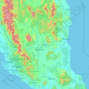
Nom : Carte topographique Pahang, altitude, relief.
Lieu : Pahang, Malaysia (2.45829 101.33159 4.78112 104.22334)
Altitude moyenne : 164 m
Altitude minimum : -2 m
Altitude maximum : 2 125 m
The highest peak, Mount Tahan, reaches 2,187 m (7,175 ft) in elevation, which is also the highest point in the Peninsular Malaysia. The climate is temperate enough to have distinct temperature variations year round, and much of the highlands are covered with tropical rainforest. Pahang is home to Malaysia's two important national parks, Taman Negara and Endau-Rompin, both located in the north and south of the state respectively. These large primary rainforests are extensive, and are home to many rare or endangered animals, such as the tapir, kancil, tigers, elephants and leopards. Ferns are also extremely common, mainly due to the high humidity and fog that permeates the area. Popular hill resorts located along these main highland areas are Cameron Highlands, Genting Highlands, Fraser's Hill and Bukit Tinggi. The Cameron Highlands is home to extensive tea plantations and also a major supplier of legumes and vegetables to both Malaysia and Singapore. The largest FELDA's palm oil plantations in Malaysia are located in Jengka Triangle centred around the Bandar Tun Razak in Maran district.
Autres cartes topographiques
Cliquez sur une carte pour visualiser sa topographie, son altitude et son relief.
Ayer Keroh
Ayer Keroh, Hang Tuah Jaya Municipal Council, Central Malacca, Malacca, 75450, Malaysia
Altitude moyenne : 21 m
South-West
Malaysia > Penang > George Town
South-West, George Town, Penang, Malaysia
Altitude moyenne : 55 m
Kuala Penyu
Malaysia > Sabah > Kuala Penyu
Kuala Penyu, Interior Division, Sabah, 89740, Malaysia
Altitude moyenne : 8 m
Timah Tasoh Reservoir
Timah Tasoh Reservoir, Perlis, Malaysia
Altitude moyenne : 32 m
Sungai Besar
Sungai Besar, Sabak Bernam, Selangor, 45300, Malaysia
Altitude moyenne : 3 m
Rantau
Rantau, Seremban, Negeri Sembilan, 71200, Malaysia
Altitude moyenne : 38 m
Klang Municipal Council
Klang Municipal Council, Klang, Selangor, Malaysia
Altitude moyenne : 12 m
Kampung Istana
Malaysia > Johor > Batu Pahat
Kampung Istana, Batu Pahat, Johor, 83000, Malaysia
Altitude moyenne : 43 m
Federal Territory of Kuala Lumpur
Federal Territory of Kuala Lumpur, Malaysia
Altitude moyenne : 119 m
Kampung Periuk
Kampung Periuk, Kampong Bharu, Kuala Lumpur, 50300, Malaysia
Altitude moyenne : 47 m
Gelang Patah
Malaysia > Johor > Iskandar Puteri
Gelang Patah, Iskandar Puteri, Johor Bahru, Iskandar Malaysia, Johor, 81550, Malaysia
Altitude moyenne : 17 m
Selayang Municipal Council
Selayang Municipal Council, Gombak, Selangor, Malaysia
Altitude moyenne : 236 m
Sungai Baleh
Malaysia > Sarawak > Nanga Gaat
Sungai Baleh, Nanga Gaat, Sarawak, Malaysia
Altitude moyenne : 188 m
Johor Bahru
Johor Bahru, Iskandar Malaysia, Johor, 80350, Malaysia
Altitude moyenne : 28 m
Sri Aman Division
Malaysia > Sarawak > Simanggang
Sri Aman Division, Simanggang, Sarawak, 95000, Malaysia
Altitude moyenne : 84 m
Kuala Lumpur International Airport
Kuala Lumpur International Airport, Selangor, 64000, Malaysia
Altitude moyenne : 13 m
Batu Dam
Malaysia > Selangor > Selayang Municipal Council
Batu Dam, Taman Jasa Utama, Selayang Municipal Council, Gombak, Selangor, Malaysia
Altitude moyenne : 141 m
Ampang Jaya Municipal Council
Ampang Jaya Municipal Council, Hulu Langat, Selangor, 55300, Malaysia
Altitude moyenne : 167 m
Kajang Municipal Council
Kajang Municipal Council, Hulu Langat, Selangor, Malaysia
Altitude moyenne : 198 m
Iskandar Puteri
Iskandar Puteri, Johor Bahru, Iskandar Malaysia, Johor, Malaysia
Altitude moyenne : 26 m
Manek Urai
Malaysia > Kelantan > Manek Urai
Manek Urai, Kuala Krai, Kelantan, Malaysia
Altitude moyenne : 62 m
Kampung Patau-Patau II (Water Village)
Kampung Patau-Patau II (Water Village), Victoria, Labuan, 87009, Malaysia
Altitude moyenne : 7 m