
Carte topographique Garland
Carte interactive
Cliquez sur la carte pour afficher l’altitude.
À propos de cette carte
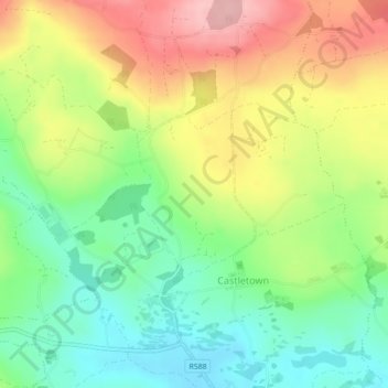
Nom : Carte topographique Garland, altitude, relief.
Altitude moyenne : 140 m
Altitude minimum : 74 m
Altitude maximum : 225 m
Autres cartes topographiques
Cliquez sur une carte pour visualiser sa topographie, son altitude et son relief.
The Municipal District of Bandon-Kinsale
The Municipal District of Bandon-Kinsale, Comté de Cork, Munster, Irlande
Altitude moyenne : 69 m
Donegal
Donegal, Cobh Rural ED, Municipal District of Cobh, Comté de Cork, Munster, Irlande
Altitude moyenne : 31 m