
Carte topographique Stakčín
Carte interactive
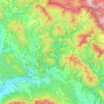
Cliquez sur la carte pour afficher l’altitude.
À propos de cette carte
Nom : Carte topographique Stakčín, altitude, relief.
Altitude moyenne : 471 m
Altitude minimum : 181 m
Altitude maximum : 1 147 m
The municipality lies in the Cirocha river valley, at an altitude of 257 metres and with a total area of 167.742 km2. According to the 2013 census it had a population of 2452 inhabitants. It lies between the Vihorlat and Bukovské vrchy mountains. The municipality is the seat of the Poloniny National Park governing body.
Autres cartes topographiques
Cliquez sur une carte pour visualiser sa topographie, son altitude et son relief.
Vyškov
Slovakia > Region of Prešov > District of Snina > Belá nad Cirochou
Vyškov, Belá nad Cirochou, District of Snina, Region of Prešov, 067 81, Slovakia
Altitude moyenne : 336 m