
Carte topographique Banská Bystrica
Carte interactive
Cliquez sur la carte pour afficher l’altitude.
À propos de cette carte
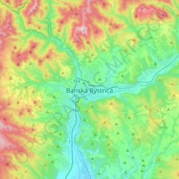
Nom : Carte topographique Banská Bystrica, altitude, relief.
Altitude moyenne : 566 m
Altitude minimum : 309 m
Altitude maximum : 1 140 m
Banská Bystrica lies at an altitude of 362 metres (1,188 ft) above sea level and covers an area of 103.37 square kilometres (39.9 sq mi). It is about halfway between Slovakia's two largest cities, 208 kilometres (129 mi) north-east from Slovakia's capital Bratislava and 217 kilometres (135 mi) west of Košice. A chain of discrete suburbs and villages connects it with Zvolen, another major town 20 kilometres (12 mi) to the south.