
Carte topographique Kimberley
Carte interactive
Cliquez sur la carte pour afficher l’altitude.
À propos de cette carte
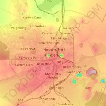
Nom : Carte topographique Kimberley, altitude, relief.
Altitude moyenne : 1 203 m
Altitude minimum : 1 076 m
Altitude maximum : 1 283 m
Kimberley is set in a relatively flat landscape with no prominent topographic features within the urban limits. The only "hills" are debris dumps generated by more than a century of diamond mining. From the 1990s these were being recycled and poured back into De Beers Mine (by 2010 it was filled to within a few tens of metres of the surface). Certain of the mine dumps, in the vicinity of the Big Hole, have been proclaimed as heritage features and are to be preserved as part of the historic industrial landscape of Kimberley.
Autres cartes topographiques
Cliquez sur une carte pour visualiser sa topographie, son altitude et son relief.
Magareng Local Municipality
South Africa > Northern Cape > Frances Baard District Municipality
Magareng Local Municipality, Frances Baard District Municipality, Northern Cape, 8530, South Africa
Altitude moyenne : 1 172 m
Barkly West
South Africa > Northern Cape > Frances Baard District Municipality > Dikgatlong Local Municipality > Barkly West
Barkly West, Dikgatlong Local Municipality, Frances Baard District Municipality, Northern Cape, 8375, South Africa
Altitude moyenne : 1 120 m
Diamandveld
South Africa > Northern Cape > Frances Baard District Municipality > Dikgatlong Local Municipality
Diamandveld, Dikgatlong Ward 5, Dikgatlong Local Municipality, Frances Baard District Municipality, Northern Cape, 8377, South Africa
Altitude moyenne : 1 035 m