
Carte topographique Veľký Klíž
Carte interactive
Cliquez sur la carte pour afficher l’altitude.
À propos de cette carte
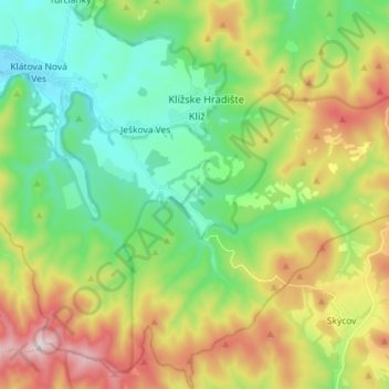
Nom : Carte topographique Veľký Klíž, altitude, relief.
Altitude moyenne : 383 m
Altitude minimum : 195 m
Altitude maximum : 723 m
The municipality lies at an altitude of 250 metres and covers an area of 42.405 km2. It has a population of about 916 people.
Autres cartes topographiques
Cliquez sur une carte pour visualiser sa topographie, son altitude et son relief.
Partizánske
Slovakia > Region of Trenčín > District of Partizánske
Partizánske, District of Partizánske, Region of Trenčín, Western Slovakia, Slovakia
Altitude moyenne : 239 m