
Carte topographique Heidenau
Cliquez sur la carte pour afficher l’altitude.
À propos de cette carte
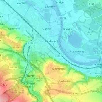
Nom : Carte topographique Heidenau, altitude, relief.
Lieu : Heidenau, Sächsische Schweiz-Osterzgebirge, Saxony, Germany (50.94354 13.82100 50.99294 13.90658)
Altitude moyenne : 150 m
Altitude minimum : 110 m
Altitude maximum : 267 m
Autres cartes topographiques
Cliquez sur une carte pour visualiser sa topographie, son altitude et son relief.
Saxon Switzerland
Germany > Saxony > Sächsische Schweiz-Osterzgebirge
Saxon Switzerland forms the northern part of the Elbe Sandstone Mountains range, located on the German-Czech border. To the east, it transitions into the Lusatian Highlands and, to the west, into the Ore Mountains. The Czech part of the Elbe Sandstone Mountains is partly formed by the Bohemian Switzerland…
Altitude moyenne : 341 m
Reinhardtsgrimma
Germany > Saxony > Sächsische Schweiz-Osterzgebirge > Glashütte
Altitude moyenne : 372 m
Berreuth
Germany > Saxony > Sächsische Schweiz-Osterzgebirge > Dippoldiswalde
Altitude moyenne : 388 m
Topograph
Germany > Saxony > Sächsische Schweiz-Osterzgebirge > Rosenthal-Bielatal
Altitude moyenne : 385 m