
Carte topographique Huancayo
Carte interactive
Cliquez sur la carte pour afficher l’altitude.
À propos de cette carte
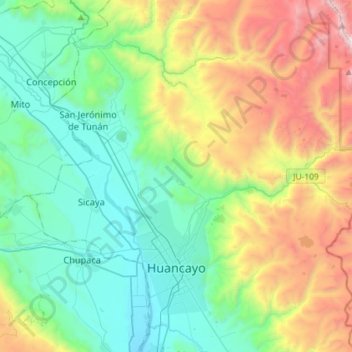
Nom : Carte topographique Huancayo, altitude, relief.
Lieu : Huancayo, Province of Huancayo, Junín, Peru (-12.08765 -75.23616 -11.90127 -74.94656)
Altitude moyenne : 3 817 m
Altitude minimum : 3 161 m
Altitude maximum : 5 379 m
Autres cartes topographiques
Cliquez sur une carte pour visualiser sa topographie, son altitude et son relief.
Barrio Independencia
Barrio Independencia, San José de Quero, Province of Concepción, Junín, Peru
Altitude moyenne : 3 987 m
Chanchamayo
Peru > Junín > Santo Domingo de Acobamba > Chanchamayo
Chanchamayo, Santo Domingo de Acobamba, Province of Huancayo, Junín, Peru
Altitude moyenne : 2 582 m
Carhuamayo
Peru > Junín > Carhuamayo
Carhuamayo, Province of Junín, Junín, Peru
Altitude moyenne : 4 248 m