
Carte topographique Dun-le-Poëlier
Carte interactive
Cliquez sur la carte pour afficher l’altitude.
À propos de cette carte
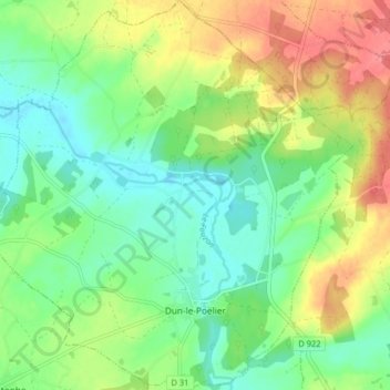
Nom : Carte topographique Dun-le-Poëlier, altitude, relief.
Altitude moyenne : 112 m
Altitude minimum : 85 m
Altitude maximum : 155 m
Autres cartes topographiques
Cliquez sur une carte pour visualiser sa topographie, son altitude et son relief.
Villiers
France > Centre-Val de Loire > Indre
Villiers, Le Blanc, Indre, Centre-Val de Loire, Metropolitan France, 36290, France
Altitude moyenne : 131 m
Roy
France > Centre-Val de Loire > Indre > Sainte-Gemme
Roy, Sainte-Gemme, Le Blanc, Indre, Centre-Val de Loire, Metropolitan France, 36500, France
Altitude moyenne : 104 m
Lacs
France > Centre-Val de Loire > Indre
Lacs, La Châtre, Indre, Centre-Val de Loire, Metropolitan France, 36400, France
Altitude moyenne : 224 m
Chavin
France > Centre-Val de Loire > Indre > Chavin
Chavin, Châteauroux, Indre, Centre-Val de Loire, Metropolitan France, 36200, France
Altitude moyenne : 230 m
Châteauroux
France > Centre-Val de Loire > Indre > Châteauroux
Châteauroux, Indre, Centre-Val de Loire, Metropolitan France, 36000, France
Altitude moyenne : 153 m
La Châtre
France > Centre-Val de Loire > Indre
La Châtre, Indre, Centre-Val de Loire, Metropolitan France, 36400, France
Altitude moyenne : 236 m