
Faire un don
Équipez-vous pour votre prochaine aventure :
En tant que Partenaire Amazon, ce site perçoit une commission sur les achats éligibles sans surcoût pour vous.
Carte topographique Aluva
Cliquez sur la carte pour afficher l’altitude.
Faire un don
Équipez-vous pour votre prochaine aventure :
En tant que Partenaire Amazon, ce site perçoit une commission sur les achats éligibles sans surcoût pour vous.
Aluva
Aluva Railway Station (IR Code: AWY) is a grade-A station and the third busiest in Kochi after Ernakulam Junction railway station and Ernakulam Town railway station. Every passenger and express train bound for southern Kerala stops here. Travelers from the Idukki district typically use either the Aluva or the Tripunithura railway station, as the topography of Idukki does not allow for a railway station. Notably, no trains originate or terminate at Aluva Railway Station. The station is situated at the junction of Railway Station Road near the KSRTC stand, which provides connections via KSRTC buses and City Low Floor buses (with and without A/C) to serve most locations in Kerala.
Faire un don
Équipez-vous pour votre prochaine aventure :
En tant que Partenaire Amazon, ce site perçoit une commission sur les achats éligibles sans surcoût pour vous.
À propos de cette carte
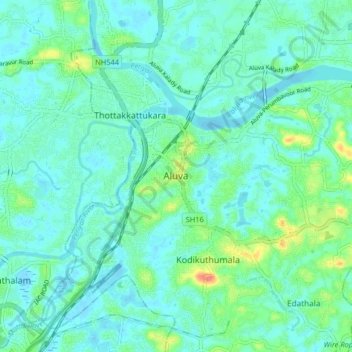
Nom : Carte topographique Aluva, altitude, relief.
Lieu : Aluva, Ernakulam, Kerala, 683101, India (10.06777 76.31685 10.14777 76.39685)
Altitude moyenne : 11 m
Altitude minimum : -2 m
Altitude maximum : 52 m
Faire un don
Équipez-vous pour votre prochaine aventure :
En tant que Partenaire Amazon, ce site perçoit une commission sur les achats éligibles sans surcoût pour vous.
Autres cartes topographiques
Cliquez sur une carte pour visualiser sa topographie, son altitude et son relief.