
Carte topographique Kwai Chung
Carte interactive
Cliquez sur la carte pour afficher l’altitude.
À propos de cette carte
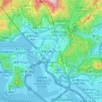
Nom : Carte topographique Kwai Chung, altitude, relief.
Altitude moyenne : 133 m
Altitude minimum : -24 m
Altitude maximum : 741 m
Autres cartes topographiques
Cliquez sur une carte pour visualiser sa topographie, son altitude et son relief.
Kau Wa Keng San Tsuen
China > Hong Kong > Kwai Tsing District
Kau Wa Keng San Tsuen, Kau Wa Keng, Kwai Tsing District, New Territories, Hong Kong, China
Altitude moyenne : 62 m