
Carte topographique Qingxin District
Carte interactive
Cliquez sur la carte pour afficher l’altitude.
À propos de cette carte
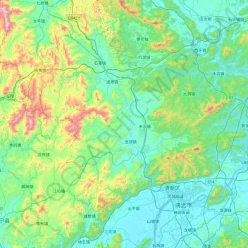
Nom : Carte topographique Qingxin District, altitude, relief.
Lieu : Qingxin District, Qingyuan City, Guangdong Province, China (23.54780 112.56313 24.31856 113.10660)
Altitude moyenne : 258 m
Altitude minimum : 3 m
Altitude maximum : 1 397 m
Autres cartes topographiques
Cliquez sur une carte pour visualiser sa topographie, son altitude et son relief.
Shangdong
China > Guangdong Province > Qingyuan City
Shangdong, Qingyuan City, Guangdong Province, China
Altitude moyenne : 494 m