
Carte topographique Málaga
Carte interactive
Cliquez sur la carte pour afficher l’altitude.
À propos de cette carte
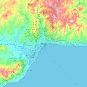
Nom : Carte topographique Málaga, altitude, relief.
Lieu : Málaga, Málaga-Costa del Sol, Malaga, Andalusia, 29008, Spain (36.56130 -4.58164 36.88130 -4.26164)
Altitude moyenne : 215 m
Altitude minimum : -1 m
Altitude maximum : 1 019 m
Like many of the military fortifications that were constructed in Islamic Spain, the Alcazaba of Málaga featured a quadrangular plan. It was protected by an outer and inner wall, both supported by rectangular towers, between which a covered walkway led up the slope to the Gibralfaro (this was the only exchange between the two sites). Due to its rough and awkward hillside topography, corridors throughout the site provided a means of communications for administrative and defensive operations, also affording privacy to the palatial residential quarters.
Autres cartes topographiques
Cliquez sur une carte pour visualiser sa topographie, son altitude et son relief.
Carretera de Cádiz
Spain > Andalusia > Málaga-Costa del Sol > Málaga
Carretera de Cádiz, Málaga, Málaga-Costa del Sol, Malaga, Andalusia, Spain
Altitude moyenne : 8 m
Este
Spain > Andalusia > Málaga-Costa del Sol > Málaga
Este, Málaga, Málaga-Costa del Sol, Malaga, Andalusia, Spain
Altitude moyenne : 423 m
Campanillas
Spain > Andalusia > Málaga-Costa del Sol > Málaga
Campanillas, Málaga, Málaga-Costa del Sol, Malaga, Andalusia, Spain
Altitude moyenne : 108 m
Pinares de San Antón
Spain > Andalusia > Málaga-Costa del Sol > Málaga
Pinares de San Antón, Este, Málaga, Málaga-Costa del Sol, Malaga, Andalusia, Spain
Altitude moyenne : 161 m
Centro
Spain > Andalusia > Málaga-Costa del Sol > Málaga
Centro, Málaga, Málaga-Costa del Sol, Malaga, Andalusia, Spain
Altitude moyenne : 26 m
Puerto de la Torre
Spain > Andalusia > Málaga-Costa del Sol > Málaga
Puerto de la Torre, Málaga, Málaga-Costa del Sol, Malaga, Andalusia, Spain
Altitude moyenne : 196 m