
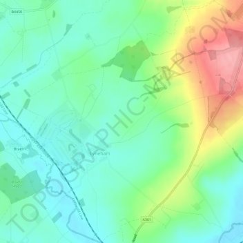
Carte topographique Lyneham
Carte interactive
Cliquez sur la carte pour afficher l’altitude.
À propos de cette carte
Nom : Carte topographique Lyneham, altitude, relief.
Altitude moyenne : 130 m
Altitude minimum : 93 m
Altitude maximum : 213 m
Autres cartes topographiques
Cliquez sur une carte pour visualiser sa topographie, son altitude et son relief.
Alvescot
United Kingdom > England > Oxfordshire > West Oxfordshire
Alvescot, West Oxfordshire, Oxfordshire, England, United Kingdom
Altitude moyenne : 87 m
Lew
United Kingdom > England > Oxfordshire > West Oxfordshire
Lew, West Oxfordshire, Oxfordshire, England, United Kingdom
Altitude moyenne : 79 m
Ramsden
United Kingdom > England > Oxfordshire > West Oxfordshire
Ramsden, West Oxfordshire, Oxfordshire, England, United Kingdom
Altitude moyenne : 136 m
Cassington
United Kingdom > England > Oxfordshire > West Oxfordshire > Cassington
Cassington, West Oxfordshire, Oxfordshire, England, United Kingdom
Altitude moyenne : 72 m
Mount Skippett
United Kingdom > England > Oxfordshire > West Oxfordshire > Ramsden
Mount Skippett, Ramsden, West Oxfordshire, Oxfordshire, England, OX7 3AP, United Kingdom
Altitude moyenne : 135 m
Standlake
United Kingdom > England > Oxfordshire > West Oxfordshire
Standlake, West Oxfordshire, Oxfordshire, England, United Kingdom
Altitude moyenne : 67 m
Shipton-under-Wychwood
United Kingdom > England > Oxfordshire > West Oxfordshire
Shipton-under-Wychwood, West Oxfordshire, Oxfordshire, England, OX7 6DE, United Kingdom
Altitude moyenne : 131 m
Chadlington
United Kingdom > England > Oxfordshire > West Oxfordshire
Chadlington, West Oxfordshire, Oxfordshire, England, United Kingdom
Altitude moyenne : 161 m
Windrush
United Kingdom > England > Oxfordshire > West Oxfordshire > Witney
Windrush, Witney, West Oxfordshire, Oxfordshire, South East England, England, OX28 4DG, United Kingdom
Altitude moyenne : 87 m
Burford
United Kingdom > England > Oxfordshire > West Oxfordshire > Fulbrook
Burford, Fulbrook, West Oxfordshire, Oxfordshire, England, United Kingdom
Altitude moyenne : 129 m
Woodstock
United Kingdom > England > Oxfordshire > West Oxfordshire > Woodstock
Woodstock, West Oxfordshire, Oxfordshire, South East England, England, United Kingdom
Altitude moyenne : 96 m
Brize Norton
United Kingdom > England > Oxfordshire > West Oxfordshire
Brize Norton, West Oxfordshire, Oxfordshire, England, United Kingdom
Altitude moyenne : 97 m
Enstone
United Kingdom > England > Oxfordshire > West Oxfordshire
Enstone, West Oxfordshire, Oxfordshire, England, United Kingdom
Altitude moyenne : 160 m
Chipping Norton
United Kingdom > England > Oxfordshire > West Oxfordshire > Chipping Norton
Chipping Norton, West Oxfordshire, Oxfordshire, England, United Kingdom
Altitude moyenne : 194 m
Stanton Harcourt
United Kingdom > England > Oxfordshire > West Oxfordshire > Stanton Harcourt
Stanton Harcourt, West Oxfordshire, Oxfordshire, England, United Kingdom
Altitude moyenne : 67 m
Kingham
United Kingdom > England > Oxfordshire > West Oxfordshire
Kingham, West Oxfordshire, Oxfordshire, England, United Kingdom
Altitude moyenne : 130 m
Eynsham
United Kingdom > England > Oxfordshire > West Oxfordshire
Eynsham, West Oxfordshire, Oxfordshire, England, United Kingdom
Altitude moyenne : 75 m
Witney
United Kingdom > England > Oxfordshire > West Oxfordshire
Witney, West Oxfordshire, Oxfordshire, England, United Kingdom
Altitude moyenne : 92 m
Taynton
United Kingdom > England > Oxfordshire > West Oxfordshire
Taynton, West Oxfordshire, Oxfordshire, England, United Kingdom
Altitude moyenne : 152 m
Wilcote
United Kingdom > England > Oxfordshire > West Oxfordshire
Wilcote, North Leigh, West Oxfordshire, Oxfordshire, England, OX7 3EB, United Kingdom
Altitude moyenne : 117 m