
Carte topographique Beulaville
Carte interactive
Cliquez sur la carte pour afficher l’altitude.
À propos de cette carte
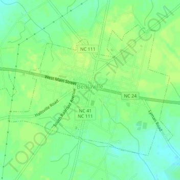
Nom : Carte topographique Beulaville, altitude, relief.
Lieu : Beulaville, Duplin County, North Carolina, United States (34.91302 -77.79222 34.93343 -77.75812)
Altitude moyenne : 27 m
Altitude minimum : 18 m
Altitude maximum : 31 m
Beulaville is located on the coastal plain of North Carolina in Duplin County. It is situated at 85 feet (26 m) above sea level, with only minimal changes in topography. Limestone Creek, a small body of water that runs into the Northeast Cape Fear River at Hallsville, borders the western boundary of town. Beulaville is 90 miles (140 km) southeast of Raleigh and 312 miles (502 km) south of Washington, D.C. The town's coordinates are 34°55′25″N 77°46′27″W / 34.92361°N 77.77417°W / 34.92361; -77.77417 (34.923533, -77.774053).