
Carte topographique Recherche
Carte interactive
Cliquez sur la carte pour afficher l’altitude.
À propos de cette carte
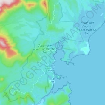
Nom : Carte topographique Recherche, altitude, relief.
Lieu : Recherche, Huon Valley, Tasmania, Australia (-43.59822 146.80032 -43.46299 146.94478)
Altitude moyenne : 80 m
Altitude minimum : -3 m
Altitude maximum : 771 m
Autres cartes topographiques
Cliquez sur une carte pour visualiser sa topographie, son altitude et son relief.
Elizabeth Town
Elizabeth Town, Meander Valley, Tasmania, 7304, Australia
Altitude moyenne : 214 m
Lake St Clair
Lake St Clair, Central Highlands, Tasmania, Australia
Altitude moyenne : 909 m
Lake Louise
Lake Louise, Grindelwald, West Tamar, Tasmania, Australia
Altitude moyenne : 124 m
Garden Island
Garden Island, Huon Valley, Tasmania, Australia
Altitude moyenne : 9 m
Mole Creek
Mole Creek, Meander Valley, Tasmania, 7304, Australia
Altitude moyenne : 440 m
Launceston
Launceston, City of Launceston, Tasmania, Australia
Altitude moyenne : 194 m
Mount Field
Mount Field, Derwent Valley, Tasmania, 7140, Australia
Altitude moyenne : 720 m
Lake Margaret
Australia > Tasmania > Lake Margaret
Lake Margaret, West Coast, Tasmania, Australia
Altitude moyenne : 761 m
Bream Creek
Australia > Tasmania > Bream Creek
Bream Creek, Sorell, Tasmania, Australia
Altitude moyenne : 35 m
Cradle Mountain
Cradle Mountain, Kentish, Tasmania, Australia
Altitude moyenne : 760 m
Binalong Bay
Binalong Bay, Break O'Day, Tasmania, Australia
Altitude moyenne : 31 m
Great Lake
Great Lake, Central Highlands, Tasmania, Australia
Altitude moyenne : 1 095 m
Strathgordon
Strathgordon, Derwent Valley, Tasmania, 7139, Australia
Altitude moyenne : 388 m
North Scottsdale
North Scottsdale, Dorset, Tasmania, 7260, Australia
Altitude moyenne : 103 m
Prospect Vale
Australia > Tasmania > Launceston
Prospect Vale, Launceston, Meander Valley, Tasmania, 7250, Australia
Altitude moyenne : 174 m
Mount Tyndall
Mount Tyndall, West Coast, Tasmania, Australia
Altitude moyenne : 910 m
Beauty Point
Beauty Point, West Tamar, Tasmania, Australia
Altitude moyenne : 20 m
West Gawler River
Australia > Tasmania > Sprent > Gawler
West Gawler River, Gawler, Sprent, Central Coast, Tasmania, Australia
Altitude moyenne : 201 m
Wellington Park
Wellington Park, Derwent Valley, Tasmania, 7054, Australia
Altitude moyenne : 419 m
Mount Ossa
Mount Ossa, Meander Valley, Tasmania, Australia
Altitude moyenne : 1 218 m
Walls Of Jerusalem
Walls Of Jerusalem, Tasmania, Australia
Altitude moyenne : 1 284 m
Roger River
Australia > Tasmania > Roger River
Roger River, Circular Head, Tasmania, Australia
Altitude moyenne : 131 m
Goose Island
Goose Island, Flinders Council, Tasmania, Australia
Altitude moyenne : 1 m