
Carte topographique Rishikesh
Carte interactive
Cliquez sur la carte pour afficher l’altitude.
À propos de cette carte
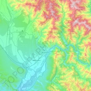
Nom : Carte topographique Rishikesh, altitude, relief.
Lieu : Rishikesh, Dehradun, Uttarakhand, India (29.96311 78.03623 30.30848 78.30998)
Altitude moyenne : 808 m
Altitude minimum : 288 m
Altitude maximum : 2 203 m
Rishikesh is at 30°06′12″N 78°17′41″E / 30.103368°N 78.294754°E / 30.103368; 78.294754. It has an average elevation of 340 metres (1,120 ft). The town is located in the Tehri Garhwal region of the northern Indian state of Uttarakhand.
Autres cartes topographiques
Cliquez sur une carte pour visualiser sa topographie, son altitude et son relief.
Kashipur
India > Uttarakhand > Kashipur
Kashipur, Udham Singh Nagar District, Uttarakhand, 244713, India
Altitude moyenne : 233 m
Naini Lake
India > Uttarakhand > Nainital > Nainital
Naini Lake, Talllital, Nainital, Nainital District, Uttarakhand, India
Altitude moyenne : 2 057 m
Paharpani
India > Uttarakhand > Dhari > Mahtoligaon
Paharpani, Mahtoligaon, Dhari, Nainital District, Uttarakhand, India
Altitude moyenne : 1 918 m
Betalghat
Betalghat, Nainital District, Uttarakhand, 263134, India
Altitude moyenne : 1 446 m
Joshimath
India > Uttarakhand > Joshimath Tehsil
Joshimath, Joshimath Tehsil, Chamoli District, Uttarakhand, India
Altitude moyenne : 2 272 m
Barsu
India > Uttarakhand > Bhatwari
Barsu, Bhatwari, Uttarkashi district, Uttarakhand, India
Altitude moyenne : 2 322 m
Bhimtal
India > Uttarakhand > Nainital
Bhimtal, Nainital, Uttarakhand, 263136, India
Altitude moyenne : 1 458 m
Dhamas
India > Uttarakhand > Almora
Dhamas, Almora, Uttarakhand, 263601, India
Altitude moyenne : 1 387 m
Mukteshwar
India > Uttarakhand > Dhari
Mukteshwar, Dhari, Nainital, Uttarakhand, 263138, India
Altitude moyenne : 1 982 m
Kumali
India > Uttarakhand > Narendra Nagar
Kumali, Narendra Nagar, Tehri Garhwal, Uttarakhand, India
Altitude moyenne : 1 200 m
Chandrashila
India > Uttarakhand > Pokhari > Bhulkhana Chatti
Chandrashila, NH107A, Bhulkhana Chatti, Pokhari, Chamoli district, Uttarakhand, India
Altitude moyenne : 3 120 m
Thali
India > Uttarakhand > Dhari
Thali, Dhari, Nainital District, Uttarakhand, India
Altitude moyenne : 1 889 m
Bharatpur
India > Uttarakhand > Bharatpur
Bharatpur, Nainital, Uttarakhand, 263136, India
Altitude moyenne : 1 447 m
Dehradun
India > Uttarakhand > Dehradun
Dehradun, Dehradun District, Uttarakhand, 248001, India
Altitude moyenne : 904 m
Dharchula
Dharchula, Pithoragarh, Uttarakhand, 262545, India
Altitude moyenne : 4 011 m
Lansdowne
Lansdowne, Pauri Garhwal District, Uttarakhand, India
Altitude moyenne : 1 025 m
Dunk
India > Uttarakhand > Dunk
Dunk, Pauri, Pauri Garhwal, Uttarakhand, India
Altitude moyenne : 949 m
Bageshwar
Bageshwar, Bageshwar District, Uttarakhand, India
Altitude moyenne : 1 398 m
Bhaniyawala
India > Uttarakhand > Bhaniyawala
Bhaniyawala, Dehra Dūn, Dehradun, Uttarakhand, India
Altitude moyenne : 510 m
Dhārchula
India > Uttarakhand > Dhārchula
Dhārchula, Pithoragarh, Uttarakhand, India
Altitude moyenne : 1 579 m