
Carte topographique Ainsworth Hot Springs
Carte interactive
Cliquez sur la carte pour afficher l’altitude.
À propos de cette carte
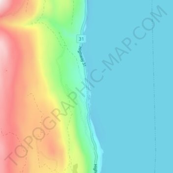
Nom : Carte topographique Ainsworth Hot Springs, altitude, relief.
Altitude moyenne : 741 m
Altitude minimum : 520 m
Altitude maximum : 1 338 m
Autres cartes topographiques
Cliquez sur une carte pour visualiser sa topographie, son altitude et son relief.
Cooper Creek
Canada > British Columbia > Regional District of Central Kootenay > Area D (Lardeau Valley/Duncan Lake)
Cooper Creek, Area D (Lardeau Valley/Duncan Lake), Regional District of Central Kootenay, British Columbia, Canada
Altitude moyenne : 1 573 m
Poplar Creek
Canada > British Columbia > Regional District of Central Kootenay > Area D (Lardeau Valley/Duncan Lake)
Poplar Creek, Area D (Lardeau Valley/Duncan Lake), Regional District of Central Kootenay, British Columbia, Canada
Altitude moyenne : 1 732 m
Silent Pass
Canada > British Columbia > Regional District of Central Kootenay > Area D (Lardeau Valley/Duncan Lake)
Silent Pass, Area D (Lardeau Valley/Duncan Lake), Regional District of Central Kootenay, British Columbia, Canada
Altitude moyenne : 2 100 m
Keen Creek
Canada > British Columbia > Regional District of Central Kootenay > Area D (Lardeau Valley/Duncan Lake)
Keen Creek, Area D (Lardeau Valley/Duncan Lake), Regional District of Central Kootenay, British Columbia, Canada
Altitude moyenne : 976 m