
Faire un don
Équipez-vous pour votre prochaine aventure :
En tant que Partenaire Amazon, ce site perçoit une commission sur les achats éligibles sans surcoût pour vous.
Carte topographique Heiligenstadt i. OFr.
Cliquez sur la carte pour afficher l’altitude.
Faire un don
Équipez-vous pour votre prochaine aventure :
En tant que Partenaire Amazon, ce site perçoit une commission sur les achats éligibles sans surcoût pour vous.
Heiligenstadt i. OFr.
Heiligenstadt lies in the Bamberg district’s southeastern corner. The 24 Gemeindeteile lie along the Leinleiter Valley and on the abutting Jura Plateau. Veilbronn lies 329 m above sea level. The greatest elevation is the Altenberg (mountain) behind Zoggendorf at 583 m above sea level. The villages on the heights from Volkmannsreuth to Teuchatz belong to the Lange Meile ("Long Mile"). The North Jura joins with the Seigelstein near Lindach. The mountain villages east of the Leinleiter are part of the Aufseßer Gebirge (mountain range).
Faire un don
Équipez-vous pour votre prochaine aventure :
En tant que Partenaire Amazon, ce site perçoit une commission sur les achats éligibles sans surcoût pour vous.
À propos de cette carte
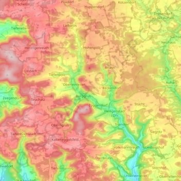
Nom : Carte topographique Heiligenstadt i. OFr., altitude, relief.
Altitude moyenne : 468 m
Altitude minimum : 317 m
Altitude maximum : 585 m
Faire un don
Équipez-vous pour votre prochaine aventure :
En tant que Partenaire Amazon, ce site perçoit une commission sur les achats éligibles sans surcoût pour vous.
Autres cartes topographiques
Cliquez sur une carte pour visualiser sa topographie, son altitude et son relief.
Wind
Germany > Bavaria > Landkreis Bamberg
Winds can shape landforms, via a variety of aeolian processes such as the formation of fertile soils, for example loess, and by erosion. Dust from large deserts can be moved great distances from its source region by the prevailing winds; winds that are accelerated by rough topography and associated with dust…
Altitude moyenne : 284 m
Faire un don
Équipez-vous pour votre prochaine aventure :
En tant que Partenaire Amazon, ce site perçoit une commission sur les achats éligibles sans surcoût pour vous.
Faire un don
Équipez-vous pour votre prochaine aventure :
En tant que Partenaire Amazon, ce site perçoit une commission sur les achats éligibles sans surcoût pour vous.