
Carte topographique Indian Lake
Carte interactive
Cliquez sur la carte pour afficher l’altitude.
Indian Lake
Indian Lake has the fourth-highest elevation of towns in Pennsylvania, at 2281 feet. This is the Lake water level, homes at Indian Lake range from 2300 to 2550 feet in base elevation.
À propos de cette carte
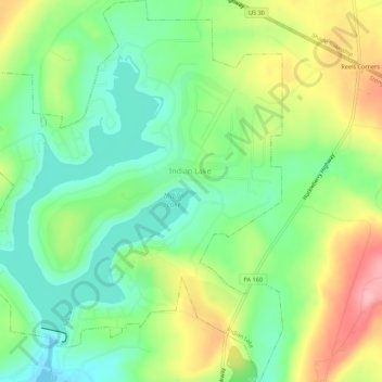
Nom : Carte topographique Indian Lake, altitude, relief.
Lieu : Indian Lake, Somerset County, Pennsylvania, United States (40.02331 -78.88721 40.06545 -78.83897)
Altitude moyenne : 732 m
Altitude minimum : 679 m
Altitude maximum : 817 m