
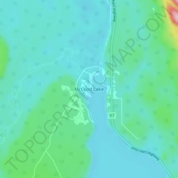
Carte topographique McLeod Lake
Carte interactive
Cliquez sur la carte pour afficher l’altitude.
À propos de cette carte
Nom : Carte topographique McLeod Lake, altitude, relief.
Altitude moyenne : 701 m
Altitude minimum : 669 m
Altitude maximum : 894 m
A point in the marshes on its southern shore of nearby Summit Lake marks the low point of the divide between the drainages of the Fraser and Peace Rivers, As such it is significant as the prominence col between all points south in the Rockies and beyond and their "parent" summits in northern BC and Alaska. Summit Lake col, at 710 m (2,330 ft) in elevation, is the low point on the mountain spine of the Americas that connects Pico de Orizaba (5,640 m (18,500 ft)) in Mexico with its next-higher "parent" peak, Mount Logan (5,959 m (19,551 ft)).
Autres cartes topographiques
Cliquez sur une carte pour visualiser sa topographie, son altitude et son relief.
Crooked River
Canada > British Columbia > Regional District of Fraser-Fort George > Area G (Crooked River/Parsnip)
Crooked River, Area G (Crooked River/Parsnip), Regional District of Fraser-Fort George, British Columbia, Canada
Altitude moyenne : 749 m
Carp Lake
Canada > British Columbia > Regional District of Fraser-Fort George > Area G (Crooked River/Parsnip)
Carp Lake, Area G (Crooked River/Parsnip), Regional District of Fraser-Fort George, British Columbia, Canada
Altitude moyenne : 865 m
Bear Lake
Canada > British Columbia > Regional District of Fraser-Fort George > Area G (Crooked River/Parsnip)
Bear Lake, Area G (Crooked River/Parsnip), Regional District of Fraser-Fort George, British Columbia, V0J 3G0, Canada
Altitude moyenne : 726 m
Tacheeda Lakes
Canada > British Columbia > Regional District of Fraser-Fort George > Area G (Crooked River/Parsnip)
Tacheeda Lakes, Area G (Crooked River/Parsnip), Regional District of Fraser-Fort George, British Columbia, Canada
Altitude moyenne : 875 m
Davie Lake
Canada > British Columbia > Regional District of Fraser-Fort George > Area G (Crooked River/Parsnip)
Davie Lake, Area G (Crooked River/Parsnip), Regional District of Fraser-Fort George, British Columbia, Canada
Altitude moyenne : 718 m
Mugaha Marsh
Canada > British Columbia > Regional District of Fraser-Fort George > Area G (Crooked River/Parsnip)
Mugaha Marsh, Area G (Crooked River/Parsnip), Regional District of Fraser-Fort George, British Columbia, Canada
Altitude moyenne : 681 m