
Faire un don
Équipez-vous pour votre prochaine aventure :
En tant que Partenaire Amazon, ce site perçoit une commission sur les achats éligibles sans surcoût pour vous.
Carte topographique Quarndon
Cliquez sur la carte pour afficher l’altitude.
Faire un don
Équipez-vous pour votre prochaine aventure :
En tant que Partenaire Amazon, ce site perçoit une commission sur les achats éligibles sans surcoût pour vous.
Quarndon
52°58′8″N 1°29′36″W / 52.96889°N 1.49333°W / 52.96889; -1.49333 This directional compass, provides details of bearings, distances, elevations and dates of nearly 50 places of special interest and was unveiled on 29 September 2001. It stands on an 8-ton block of Derbyshire gritstone – 140 metres above sea level – funded by the will of the third Viscount Scarsdale who died in 2000 aged 76.
Faire un don
Équipez-vous pour votre prochaine aventure :
En tant que Partenaire Amazon, ce site perçoit une commission sur les achats éligibles sans surcoût pour vous.
À propos de cette carte
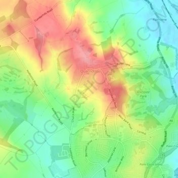
Nom : Carte topographique Quarndon, altitude, relief.
Lieu : Quarndon, Amber Valley, Derbyshire, England, United Kingdom (52.94631 -1.52417 52.97845 -1.48333)
Altitude moyenne : 96 m
Altitude minimum : 51 m
Altitude maximum : 149 m
Faire un don
Équipez-vous pour votre prochaine aventure :
En tant que Partenaire Amazon, ce site perçoit une commission sur les achats éligibles sans surcoût pour vous.
Autres cartes topographiques
Cliquez sur une carte pour visualiser sa topographie, son altitude et son relief.