
Carte topographique Sundays River Valley Ward 4
Carte interactive
Cliquez sur la carte pour afficher l’altitude.
À propos de cette carte
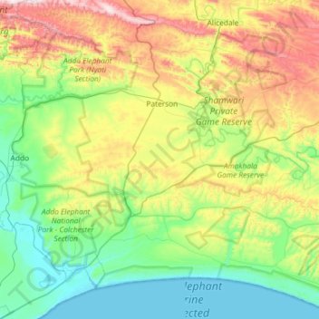
Nom : Carte topographique Sundays River Valley Ward 4, altitude, relief.
Altitude moyenne : 260 m
Altitude minimum : -1 m
Altitude maximum : 882 m
Autres cartes topographiques
Cliquez sur une carte pour visualiser sa topographie, son altitude et son relief.
Sapkamma
RSA > Eastern Cape > Sundays River Valley Local Municipality
Sapkamma, Sundays River Valley Local Municipality, Sarah Baartman District Municipality, Eastern Cape, RSA
Altitude moyenne : 356 m