
Carte topographique Rioja
Carte interactive
Cliquez sur la carte pour afficher l’altitude.
À propos de cette carte
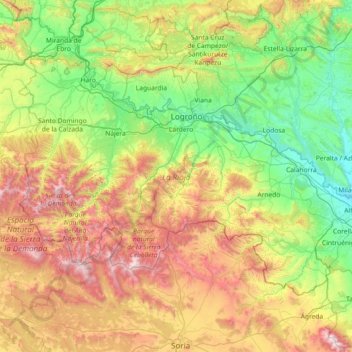
Nom : Carte topographique Rioja, altitude, relief.
Lieu : Rioja, Spain (41.91903 -3.13427 42.64426 -1.67870)
Altitude moyenne : 879 m
Altitude minimum : 270 m
Altitude maximum : 2 297 m
The mountains in La Rioja are part of the Iberian System. This mountain range extends to the south of the Ebro river, parallel to it at a distance of about 40 to 60 km (25 to 37 miles), with altitudes ranging between 1,000 and 2,000 m (3,300 and 6,600 feet). From the mountain range the Sierra de la Demanda runs northwards, into the heart of La Rioja, incorporating Monte San Lorenzo which, at 2,271 m (7,451 ft), is the highest peak in the province. Other mountains include Sierra de Camero Viejo, Sierra de Camero Nuevo, Sierra de Cebollera, and Picos de Urbión.
Autres cartes topographiques
Cliquez sur une carte pour visualiser sa topographie, son altitude et son relief.
Cuarterón
Spain > Rioja > Cervera del Río Alhama
Cuarterón, Cervera del Río Alhama, Rioja, Spain
Altitude moyenne : 720 m
San Pedro
Spain > Rioja > Laguna de Cameros
San Pedro, Laguna de Cameros, Rioja, Spain
Altitude moyenne : 1 199 m
Vega Larga
Spain > Rioja > Villavelayo
Vega Larga, Villavelayo, Rioja, Spain
Altitude moyenne : 1 262 m