
Carte topographique Rio Rancho
Carte interactive
Cliquez sur la carte pour afficher l’altitude.
À propos de cette carte
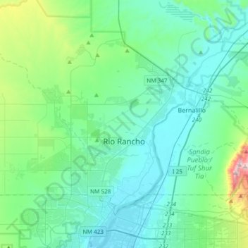
Nom : Carte topographique Rio Rancho, altitude, relief.
Lieu : Rio Rancho, Sandoval County, New Mexico, United States (35.17992 -106.86521 35.39438 -106.56700)
Altitude moyenne : 1 672 m
Altitude minimum : 1 518 m
Altitude maximum : 2 487 m
Rio Rancho is in an arid climate due to its location in the rain shadow of the Sandia Mountains to the east and the Continental Divide to the west. Rio Rancho receives 8.90 inches of precipitation annually on average. The western portion of the city receives slightly more rain and snowfall due to its higher elevation than that of the more densely developed eastern portion of Rio Rancho.
Autres cartes topographiques
Cliquez sur une carte pour visualiser sa topographie, son altitude et son relief.
Torreon
United States > New Mexico > Sandoval County
Torreon, Eastern Navajo Agency, Sandoval County, New Mexico, United States
Altitude moyenne : 1 984 m
Cabezon
United States > New Mexico > Sandoval County
Cabezon, Sandoval County, New Mexico, United States
Altitude moyenne : 1 888 m
Placitas Homesteads
United States > New Mexico > Sandoval County
Placitas Homesteads, Sandoval County, New Mexico, 87043, United States
Altitude moyenne : 1 694 m