
Faire un don
Équipez-vous pour votre prochaine aventure :
En tant que Partenaire Amazon, ce site perçoit une commission sur les achats éligibles sans surcoût pour vous.
Carte topographique Cardrona
Cliquez sur la carte pour afficher l’altitude.
Faire un don
Équipez-vous pour votre prochaine aventure :
En tant que Partenaire Amazon, ce site perçoit une commission sur les achats éligibles sans surcoût pour vous.
À propos de cette carte
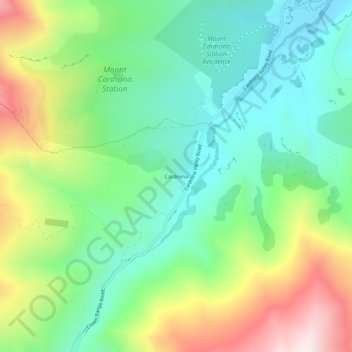
Nom : Carte topographique Cardrona, altitude, relief.
Lieu : Cardrona, Queenstown-Lakes District, Otago, New Zealand (-44.90327 168.98057 -44.86327 169.02057)
Altitude moyenne : 758 m
Altitude minimum : 497 m
Altitude maximum : 1 256 m
Faire un don
Équipez-vous pour votre prochaine aventure :
En tant que Partenaire Amazon, ce site perçoit une commission sur les achats éligibles sans surcoût pour vous.
Autres cartes topographiques
Cliquez sur une carte pour visualiser sa topographie, son altitude et son relief.
The Remarkables
New Zealand > Otago > Queenstown-Lakes District
The area contains a number of beautiful features, such as Lake Alta, a small lake nestled within a natural amphitheatre at the head of a glacial valley (a ‘cirque’) and below the towering Double Cone peaks. There are a number of high altitude walks in the Remarkables Conservation Area including Lake Alta…
Altitude moyenne : 1 200 m
Queenstown
New Zealand > Otago > Queenstown-Lakes District
The town is at a relatively low altitude for a ski and snowboarding centre, at 310 metres (1,020 ft) above sea level at the lake shore, but is nestled among mountains, most notably the scenic attraction of The Remarkables, to the town's southeast. Below the lake lies the deep Kawarau Gorge, and there are…
Altitude moyenne : 713 m
Faire un don
Équipez-vous pour votre prochaine aventure :
En tant que Partenaire Amazon, ce site perçoit une commission sur les achats éligibles sans surcoût pour vous.
Lake Hāwea
New Zealand > Otago > Queenstown-Lakes District
The lake is in the Otago Region at an altitude of 348 metres. It covers 141 km² and reaches 392 metres deep.
Altitude moyenne : 864 m
Lake Wakatipu
New Zealand > Otago > Queenstown-Lakes District
With a length of 80 kilometres (50 mi), it is New Zealand's longest lake, and, at 289 km2 (112 sq mi), its third largest. The lake is also very deep, its floor being below sea level (−110 metres), with a maximum depth of 420 metres (1,380 ft). It is at an altitude of 310 metres (1,020 ft), towards the…
Altitude moyenne : 952 m