
Carte topographique Mount Rogers
Carte interactive
Cliquez sur la carte pour afficher l’altitude.
À propos de cette carte
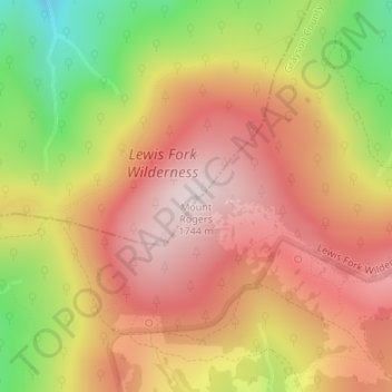
Nom : Carte topographique Mount Rogers, altitude, relief.
Lieu : Mount Rogers, Smyth County, Virginia, United States (36.65979 -81.54461 36.65989 -81.54451)
Altitude moyenne : 1 507 m
Altitude minimum : 1 180 m
Altitude maximum : 1 732 m
Mount Rogers is the highest natural point in Virginia, United States, with a summit elevation of 5,729 feet (1,746 m) above mean sea level. The summit straddles the border of Grayson and Smyth Counties, Virginia, about 6.45 miles (10.38 km) WSW of Troutdale, Virginia. Most of the mountain is contained within the Lewis Fork Wilderness, while the entire area is part of the Mount Rogers National Recreation Area, which itself is a part of the Jefferson National Forest.
Autres cartes topographiques
Cliquez sur une carte pour visualiser sa topographie, son altitude et son relief.
Marion
United States > Virginia > Smyth County
Marion, Smyth County, Virginia, 24354, United States
Altitude moyenne : 711 m
Hungry Mother State Park
United States > Virginia > Smyth County
Hungry Mother State Park, Cabin Fever Drive, Smyth County, Virginia, 24354, United States
Altitude moyenne : 783 m
Sugar Grove
United States > Virginia > Smyth County
Sugar Grove, Smyth County, Virginia, 24375, United States
Altitude moyenne : 952 m
Atkins
United States > Virginia > Smyth County
Atkins, Smyth County, Virginia, 24311, United States
Altitude moyenne : 843 m
Chilhowie
United States > Virginia > Smyth County
Chilhowie, Smyth County, Virginia, United States
Altitude moyenne : 628 m
Groseclose
United States > Virginia > Smyth County > Groseclose
Groseclose, Smyth County, Virginia, 24368, United States
Altitude moyenne : 777 m
Nebo
United States > Virginia > Smyth County > Nebo
Nebo, Smyth County, Virginia, 24318, United States
Altitude moyenne : 771 m
Saltville
United States > Virginia > Smyth County
Saltville, Smyth County, Virginia, United States
Altitude moyenne : 617 m