
Carte topographique Kamathwada
Cliquez sur la carte pour afficher l’altitude.
À propos de cette carte
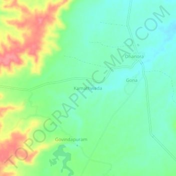
Nom : Carte topographique Kamathwada, altitude, relief.
Lieu : Kamathwada, Bheempoor Mandal, Adilabad, Telangana, India (19.77625 78.37077 19.81625 78.41077)
Altitude moyenne : 249 m
Altitude minimum : 221 m
Altitude maximum : 301 m
Autres cartes topographiques
Cliquez sur une carte pour visualiser sa topographie, son altitude et son relief.
Hyderabad
India > Telangana > Bahadurpura mandal
Hyderabad (/ˈhaɪdərəbæd/ HY-dər-ə-bad; Telugu: [ˈɦaɪ̯daraːbaːd], Urdu: [ˈɦɛːdəɾaːbaːd]) is the capital and largest city of the Indian state of Telangana. It occupies 650 km2 (250 sq mi) on the Deccan Plateau along the banks of the Musi River, in the northern part of Southern India. With an…
Altitude moyenne : 549 m
Link-I (Kaleshwaram Lift Irrigation Project, North Part)
India > Telangana > Anthergaon mandal > Goilwada
Altitude moyenne : 144 m