
Carte topographique Scopello
Carte interactive
Cliquez sur la carte pour afficher l’altitude.
Scopello
Scopello is a comune (municipality) located in the Valsesia region of the Italian Pennine Alps, administratively in the Province of Vercelli, Piedmont. The municipality covers an area of 18.62 square kilometres (7.19 sq mi) and ranges in elevation from 640 to 1,930 metres (2,100 to 6,330 ft) above sea level. It takes its name from its main centre, the small town of Scopello, which stands on the river Sesia at an elevation of 659 metres (2,162 ft).
À propos de cette carte
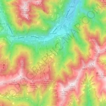
Nom : Carte topographique Scopello, altitude, relief.
Lieu : Scopello, Vercelli, Piedmont, 13028, Italy (45.71875 8.05898 45.79749 8.14081)
Altitude moyenne : 1 256 m
Altitude minimum : 595 m
Altitude maximum : 1 935 m
Autres cartes topographiques
Cliquez sur une carte pour visualiser sa topographie, son altitude et son relief.