
Carte topographique Roth
Cliquez sur la carte pour afficher l’altitude.
Roth
Bohnberg | Buch am Forst | Burgberg | Degendorf | Eichig | Friesenhof | Gnellenroth | Hammer | Heinach | Isling | Karolinenhöhe | Klosterlangheim | Kösten | Köttel | Krappenroth | Lahm | Mistelfeld | Mönchkröttendorf | Nassanger | Oberlangheim | Oberwallenstadt | Reundorf | Roth | Rothmannsthal | Schney | Schönsreuth | Seehof | Seubelsdorf | Stetten | Stöcken | Tiefenroth | Trieb | Unterwallenstadt | Weingarten
À propos de cette carte
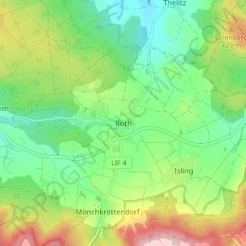
Nom : Carte topographique Roth, altitude, relief.
Altitude moyenne : 381 m
Altitude minimum : 296 m
Altitude maximum : 531 m