
Carte topographique Kisumu
Carte interactive
Cliquez sur la carte pour afficher l’altitude.
Kisumu
Kisumu literally means a place of barter trade "sumo". The city has "Friendship" status with Cheltenham, United Kingdom and "sister city" status with Roanoke, Virginia and Boulder, Colorado, United States. It sits at an elevation of 1,131 m (3,711 ft). Kisumu is 200 miles north west of Nairobi and its located at the shores of Lake Victoria. It lies at the northeastern edge of the Winam Gulf, a long, shallow arm that protrudes from the main body of Lake Victoria. Kisumu is set 15 miles south of the Equator and has moderate temperatures because of its elevation of 3000+ ft. above sea level. Just four hours away by car is the massive Kenya National Game Preserve, the Masai Mara, a world-renowned safari attraction. Kisumu is a few kilometers South of the equator, so the days are always around 12 hours long and sunset is always between 1840h and 1900h.The metropolitan region comprises the city and its suburbs and satellite towns of Maseno, Kondele and Ahero .
À propos de cette carte
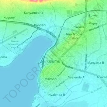
Nom : Carte topographique Kisumu, altitude, relief.
Lieu : Kisumu, Kisumu County, Nyanza, 40100, Kenya (-0.13552 34.67275 -0.03467 34.82763)
Altitude moyenne : 1 219 m
Altitude minimum : 1 132 m
Altitude maximum : 1 715 m
Autres cartes topographiques
Cliquez sur une carte pour visualiser sa topographie, son altitude et son relief.
Kisumu
Kisumu's elevation is 1,131 m (3,711 ft) and is about 320 km (200 mi) northwest of Nairobi, on the shores of Lake Victoria. It lies at the northeastern edge of the Winam Gulf, a long, shallow arm that protrudes from the main body of Lake Victoria. Kisumu is 24 km (15 mi) south of the equator and has, due to…
Altitude moyenne : 1 310 m
Kisumu
Its elevation is 1,131 m (3,711 ft) above sea level. Kisumu is about 320 km (200 mi) northwest of Nairobi and is located on the shores of Lake Victoria. It lies at the northeastern edge of the Winam Gulf, a long, shallow arm that protrudes from the main body of Lake Victoria. Kisumu is 24 km (15 mi) south of…
Altitude moyenne : 1 310 m